


4. discovering Khazaria, TEREK, before the leap.
There are two ways to prepare oneself for exploring new places. The first is to read all or almost all of the literature concerning the territory to be studied, and, armed with knowledge, ready to go.

From CHAPTER EIGHT.
Then go to the place in order to supplement and clarify the wealth accumulated by predecessors.
But there is another way, which was suggested to me in 1948 by the remarkable traveler and discoverer of Altai antiquities S.I. Rudenko.
When I was about to go with him to Altai, he recommended me not to read any special works on Altai antiquities, although there were many of them, but to limit myself to general works on the history of the period which interested me. In this way, it was easier to keep one's perception fresh and find what other travelers had missed; for seeing and perceiving are not the same thing.
Again, as four years ago, I was going to look for a Khazar city in a new area, unknown to me, but the difference was evident. Now I could rely on more than just my gut feeling. Rich experience of work on the Volga created a system of broad associations; the book on Turkic, and on Uyghur Khaganates "The Ancient Turks", which I wrote during this time, allowed me to expand my historical horizons and remember many details that elude the reader, but stick in the writer's memory; finally, the Institute, where I was invited (GENII), allocated some money for transportation, and it was possible to hire a truck for a week. I chose Kizlyar, which was situated in the center of the plain, where according to M.I. Artamonov the first capital of Khazaria, Semender, stood [7, p.399].
We were joined by V.N.Kurenoy, who worked in 1961 on Stepan Razin's hillock and he fell in love with our history. He did a masterful topographical survey, and thanks to his help we were able to conduct much more research than we initially assumed.
At the Kizlyar motor depot we hired a car with a chauffeur, who at first looked at us with distrust, but soon became [163-164] our first friend. Thus was formed a new detachment, before which opened the Terek steppes, so wide that it seemed easier to find a needle in a haystack than in this expanse of the Khazar time skeleton.
Terek
In any labyrinth there must be a thread of Ariadne. Such seemed to me Terek, the flow of which goes through Kizlyar. Brown water beats furiously on the banks and piles of the wooden bridge, but the young boys are cheerfully floundering in the waves, not paying attention to the current. Looking at them, we decided that the stories about the turbulent currents of the Terek are, as often happens, exaggerated; well, the river is like a river.
Another thing seemed interesting to me: the Terek does not flow in a depression, but on an elevation. Depositing century after century of grains of sand, it has raised its course above the surrounding plain, and only powerful dams save the houses of Kizlyar from Terek waters. But it is possible for the dam to burst, and then what? And so it happened at the moment of our arrival. The authorities were in a state of turmoil - below Kizlyar, the water had broken the dam, and all efforts were thrown to restore it. However, the residents did not seem worried, explaining to us that this happens almost every year, and the usual trouble is no trouble at all.
The first route we took was to the east of Kizlyar, downstream of the Terek. The wide plain, heated by the rays of the August sun, was occasionally crossed by walls of tall reeds. These were traces of the old channels of the Terek, which, like any river flowing in a latitudinal direction, tends to change its course. There were no monuments, no settlements here. We thought that on the right, southern bank of the Terek we would see a different picture, and indeed, when we reached the crossing below Kizlyar, we saw the sea, yes, exactly the sea, (Caspian) up to a meter and a half deep.
Having broken the dam, the Terek flooded the low part of the delta plain. And what happened when there were no dams? After all, it was even worse then! And we turned back, because it was clear that the Khazars could not be in the floodplain of the Terek.
The next day we tried again to break through to the right bank of the Terek, this time above Kizlyar. We crossed the Terek over a bridge and headed out into the flat steppe, hoping to reach the high spots on the map. After all, we were used to looking for hillocks and thought that here, too, any elevated place would bear traces of ancient habitation. [164-165]
We had to drive a long way. On the way we came across a small river, knee-deep, which our car forced without difficulty. After a few hours' journey we saw carts loaded with goods, and mountain women sitting on piles of household goods. They were driving leisurely south, where in the distance the silhouettes of the spurs of the Caucasus were blueprints.
p73
"What happened?" - we asked, and they readily explained that overnight the Terek had broken a dam somewhere below Grozny and they were moving away from the flood. There was not a trace of anxiety on their faces. The water is overflowing across the plain slower than a horse's pace. Even if the water catches up with them, they will have time to ride through the shallow water to the saving mountains. But we were no fun. Where a horse could pass without difficulty, the car would bog down, and the prospect of sitting for a week on the roof of a cabin in a sea as deep as a man's height did not appeal to us at all. We turned back on our word, and just in time. The knee-deep river had already turned into a wide river and was widening before our eyes. Shallow water was splashing in all the lowlands, previously invisible to the mere eye. The chauffeur gave off the gas and made a huge detour to get out on the highway. As we were crossing back over the bridge, the bridge guard warned us that the crossing was about to be closed and congratulated us on getting out in time.
However, we were lucky twice. At last it became clear why the ancient geographers named the Daryal gorge [7, p.63], rather than the passage along the shore of the Caspian Sea near Derbent, and why the Arabian commanders preferred the difficult route across the mountain passes to the plain of the Terek and Sulak delta, which lay between Derbent and Khazaria [Ibid, p.360, 399], for their incursions into Khazaria.
At that time, when the banks of the Terek and Sulak were not fortified and these powerful rivers roamed the plain, the danger of floods was infinitely greater than in our relatively dry time. The floods were a water barrier, impassable even for cavalry. One could wade across the river, but one could not move waist-deep in water for tens of kilometers. People and horses would get tired and fall and drown even in shallow water. The Khazars themselves could choose dry time for raids on Derbent, and as locals they knew the roads, where the water was not terrible. But the strangers could not force the floods of rivers, and they invaded from Transcaucasia through the mountains to plunder the rich city of Semender, which blocked their way into the interior.
But if so, we decided [164-165] to look for Semender and the Khazar settlements surrounding it not below, but above Kizlyar, and we turned our car to the village Grebenskaya, lying on the edge of the sand dunes, called here "burunami", and we renewed our search.
Buruns
A chain of sand ridges stretches along the highway connecting Kizlyar and Grozny. In places they are separated from the highway by dry steppe, and in some places they come almost right up to it. Having found such a place, we stopped the car and approached the sandy ridge in amazement. The dry grass framing the sandstorms and the yellow sand of the slope everywhere consisted of shards of molded crockery. They were not difficult to recognize: some of them were undoubtedly Sarmatian time, some were very similar to our Khazar finds in the Volga delta.
Taking advantage of the good road, we quickly drove around the entire southern edge of the buruns to the bend of the Terek, west of which stands the city of Grozny. We made systematic forays every 10-12 km. We found not only ceramics, but also ancient burials in the sands, blown by our faithful assistant, the wind. After all, most of the heavy objects dropped or abandoned on the surface, over time, sagged through the fine sand, and only the wind, exposing here and there a loamy soil of the mainland, helped us to find traces of ancient culture.
Gradually the picture became clearer. Settlements of the Sarmatian and Khazar times were located exclusively on the southern edge of the sands, and deeper only red, thin-walled Nogai pottery was found, left by nomads who drove their herds from the banks of the Kuma to the spring pastures. But there were very few of them, too, because for most of the year, this sun-burned desert was deserted. The question arose as to why the population on the edge of the buruns in the first millennium AD was denser than even now. What could it be due to?
Let us imagine the climatic conditions at the time when the sedentary Khazars lived here. After all, this was the era of the steppes. Terek flowed not only on the right bank, but flooded those places where Cossack villages and farms of settlers from the Ukraine now stand. And if so, it means that the Khazar settlements had to be located above the level of possible floods. That is why we find their traces [166-167] there, where now, in a relatively dry era, it does not make sense to build houses. So, geography confirms the data of archaeology, and they both together allow a historian to reconstruct a picture of the past epoch, the time of Khazar prosperity.
Khazars lived in the same places where now live Greben Cossacks, a settled tribe, who spoke the Russian language [53, p. 60-61]. According to legends preserved in folk memory, the ancestors of the Greben Cossacks settled in these places long before Ivan the Terrible (1533-1584) and helped his commanders to build the fortress of Terki on the border with the militant mountaineers of Dagestan and Chechnya, Muslims and enemies of Christians. In the 16th century, the energetic Qizilbashis, who had subjugated the pampered Persia, stretched their hand into the Caucasus, but Terek became the border for the claims of the Safavid Shahs. It should be remembered that 700 years before that the Khazars stopped the onslaught of the Arabs at the same borderline with a similar balance of power. The coincidence of circumstances could not be accidental. Terek Khazaria could only lie where stanitsa Greben Cossacks still stand.
p74
But this is only a hypothesis! It is a train of thought, prompted by general ideas about the correlation of eras, about the interaction between nature and people, about the change of wet and dry periods! No, for the idea to be proven, factual confirmation is required, fellow archaeologists would tell me. Where is the city of Semender? Where is the fortress of Terki? Until they are found, all talk of what should or could have been is worthless.
These objections I foresaw; moreover, they appeared to me as clearly as if I had heard and seen my opponent. So we turned the car around and raced to explore the strip of steppe that lay between the rushes and the coastal forests of the Terek, a strip that stretched from Grozny to the shore of the Caspian Sea for more than 200 km.
The Steppe
As we were entering the steppe bordering the Terek we took into account that only such an imperfect instrument as our eye could see the steppe as flat. The fact that in the first route we saw many dry channels showed that the bulk of the water flowed down them, and consequently there must be at least some low hills, which were not covered with water during floods. On them we expected to find [167-168] fortresses, which in the Middle Ages were always surrounded by ramparts, and therefore visible even from a great distance.
For a start we went east, to the sea, which, we think, not without reason was called in X century the Khazar. For a long time, our attention and patience were tested. Not a single hillock was visible on either side of the road. Finally, a blue stripe appeared in front of us, a warm salt sea breeze reeked and simultaneously the familiar shape - a rampart - rose from the left side of the road.
It was not a discovery. We came across a well-known, repeatedly described "Three-walled hill fort". [13, с. 228-229; 54]. Three ramparts, the southern, western and eastern, with extensions for towers, formed an irregular trapezoid, the foundation of which was missing in the "north of the fortress. It was very strange why the last wall was not built, all the more so because there were no natural barriers like the dried-up Terek riverbed even in the most ancient times. Ceramics, lying in abundance near the western rampart, were similar to the Golden Horde ceramics of the Volga region.
But most important and valuable for the dating of the fortress was the fact that the tops of the ramparts were covered with a layer of salt-water shells. There were so many of them, unbroken, lying in situ, that the version of their accidental appearance on the ramparts disappeared. It is known that mollusks feel best on the shoals, where the water is warmed by the sun. Apparently, these mollusks multiplied here, too, when the waves of the Caspian Sea slightly covered the top of the ramparts. Absolute mark of the top of the rampart was about minus 19 m, and Caspian Sea reached such level only in the second half of the XIII century. So, the "Three-walled fortress" was built in the second quarter of the XIII century, between the formation of the Golden Horde and the maximum rise of the Caspian Sea [34].
At this time the Mongol empire of Genghis Khan's successors split and the separate ulus of Genghisids entered into a fierce war between themselves. In Mongolia, Arik Buga, a protégé of the Western Mongols, fought in 1260-1264 against his brother Kubilai, who relied on an army made up of veterans who had defeated China. After Arik-buga's defeat and death, his cause was continued by Haidu, who was supported by Prince Nayan, who opposed Kublai under the banner of the cross. Among the khans who refused obedience to Kublai, expressed in the payment of a share of the collected taxes, was [168-169] Berke, Khan of the Golden Horde. He had to face Kublai's brother, the Ilkhan of Iran, Hulagu, all at once, and streams of blood poured down the valleys of Azerbaijan and Dagestan.
Until the Caspian Sea burst its banks, Berke Khan and his successors had every reason to fear a sudden strike from the south. Therefore, they tried to create a fortress in the lower reaches of the Terek for their watch detachment. But no sooner had they built the fourth rampart, than the sea flooded the steppes around the fortress and became a barrier for the enemy cavalry, much more powerful than any fortress. That is why the fortification was left unfinished, with salt-water shells on its ramparts. We could only state that it had nothing to do with the Khazars.
In the evening of the same day we found another settlement, this time on the bank of an old river near the bend of the Terek. But even at first glance it was clear what it was. The rampart in plan was an eight-pointed star with wide squares at the ends of the rays. The squares were the rascals for the guns of the XVII-XVIII centuries, when the recoil of the shot did not know how to cushion, and the bent line of the fortress wall showed the builders' familiarity with the French engineer Vauban's fortifications.
p75
It was also a guard fort, but a Russian one. It could accommodate at most a company of soldiers, but apparently it was enough to bring order to the lower reaches of Terek, after Peter the Great conquered the western and southern shores of the Caspian Sea in 1,724 and the North Caucasus became one of the internal regions of the Russian Empire.
We returned from the route, having established only that there were no Khazar settlements in the lower reaches of the Terek. The settlement near the village of Kordonovka, which the locals call "Shamil's Fortress", was of a completely different type. Of course, Shamil had nothing to do with the construction or use of this fortress. It is attributed to him by the popular custom to time all the ancient monuments to the latest major historical events, overshadowing the entire previous history. Thus, in Podolia all the Scythian and Old Russian settlement sites are considered by the locals to be Turkish in memory of the Turkish invasion of Kamenetz in 1,672, on the Volga all the cliffs are attributed to Stepan Razin, in Mongolia all the ruins are attributed to Genghis Khan.
"Shamil's fortress" is located on the bank of the old river Terek. The ramparts, made of clay, repeat the curves of the old river. They are in very poor condition, as silage pits and Cossack graves are arranged in them. The pottery lying in abundance inside [169-170] the fortress is Sarmatian, and hence we have stumbled upon one of the Alanian fortresses, where the locals were fleeing from the Huns. In those days, there was drought in the steppes, and the floods of the Terek did not threaten the Alans, who built a fortress near the water, so as not to suffer from thirst during the siege. And they were not afraid of an attack, because the Huns, terrifying in the open steppes, had never learned how to take fortresses. The find was interesting in itself, but we don't need it. Searching beyond the Khazar settlements we headed west again.
Forest
Along the northern bank of the Terek stretches a strip of dense forest about 5 km wide. This forest was unlike any other forest I had ever seen. Giant trees cover the sky with their leaves, and it's hard to believe they are poplars. Their trunks are often wrapped up to the crown with creeping plants. Low places are overgrown with rushes with gray oscillating panicles, (a kind of a plant). Thorny bushes form thickets that are difficult to pass, and when they are gone, the ground is strewn with decayed leaves and there is a chill because the branches, interlaced at the top, do not let the sunlight in.
But the most important and perhaps scariest thing about this forest is the mosquitoes. Usually, we think of mosquitoes as flying in the air, but here the air serves as a gasket between the mosquitoes. There is a gray buzzing cloud that causes the traveler a continuous pain, gradually becoming intolerable. We soaked our shirts in anti-mosquito fluid so that they fell to pieces on the second day; we smeared our faces, arms, necks, and legs so that our skin burned with fire; we put stuffy nets over our faces because mosquitoes climbed into our mouths and noses; and yet, only thanks to a graded road through the forest, heated by the rays of the sun, could we conduct our research. These little gray fiends are afraid of the sun and the heat, but where there is shade is their kingdom.
The Terek spill captured a part of the forest belt, and thanks to that we were able to see an incomparable and unrepeatable sight. In the very center of the floodplain forest the grader road cut an ancient rampart. Our chauffeur cozily settled down to read a book, while we walked along the rampart, surrounded by water on both sides. The surface of the spill, shimmering in the reflected rays, [170-171] shaded the shape of the rampart and its fanciful curves. Sometimes we had to wade across - these were the gates; sometimes the rampart rose - these were the walls of the citadel. No excavations could be made because the water depth next to the rampart was up to 1.5 m, but it must have been deeper where the ditches were. We were only able to sketch the plan and collect the shards on the side of the gravel road. And what was it? The pottery turned out to be late, and the plan repeated all the features of the Russian fort in the lower reaches of the Terek. Not the Khazars again!!!
Apparently, we stumbled upon the fortress of Terki, which often changed its place, until Kizlyar was built in 1,734, which became the capital of the Terek region. Our fortress is a magnificent monument of the time, when Terek was the border between Russia and Persia, and this lasted until 1,722, when Russian engineers, using all the achievements of European fortification, created an indestructible fortress on the border. We had to go, because the Khazar fortress had to be discovered somewhere nearby.
p76
The Last Finding
Our transportation options were coming to an end when, driving along the highway during our penultimate route, we noticed the outline of a large rampart. At this point the steppe strip between the sands and the forest was at its narrowest and highest. One kilometer lower, there were already lowlands flooded by the Terek flood.
We approached the ramparts and were taken aback. I had never seen anything like that before, even though I have described settlements from Baikal to the Carpathian Mountains. The high ramparts formed a regular square, with gates in each of the four walls. On the sides of the gate and at regular intervals on the walls there are towers, eight on each wall. The fortress was surrounded by a 50 m wide moat, long ago floated, but still clearly visible. Water into the moat came from a narrow bed of the Terek, now dried up, which surrounded the fortress from the north. The interior of the fortress was completely flat (obviously, deformed by plowing), but there we found ceramics of the 8th century. - There we found pottery of big vessels for storage of food and water. The west gate was widened by a bulldozer, exposing a section of the wall. It is made of adobe square brick, [171-172] very similar in size to the brick of Sarkel fortress, which I saw during the excavations of M.I.Artamonov in 1935. Around the fortress, which certainly was a citadel, we see many irregularities in the ground, which can be the result of ancient buildings, but everything is covered with strong turf, and the study required special work, which was impossible during the reconnaissance route. We had to limit ourselves to surveying the plan and collecting pottery.
What kind of fortress is this? - I could not decide and left this question open until we returned to Leningrad.
We still had to survey the steppes north of Kizlyar, which is how we completed the 1963 survey. The Khazars did not live outside the river valleys, because they were not nomads. However, we only believed that before, but now we have received confirmation that eliminated all doubts.
***
Autumn.
Along the sparkling rain on the embankment, I brought the plans of the fortresses to the Institute of Archaeology in order to consult with P.A. Rapoport, the best expert on medieval fortress architecture. One after another, he put off the drawings, showing no interest in them. Finally, I put the plan of the last fortress on the table. When he looked at it, he could not contain his excitement and cried out: "A Khazar fortress! And what kind of pottery is there?" - "Eighth century," I replied. "Then there's no doubt about it!"
As I walked back to the Hermitage, my head was spinning, because I realized that it was not just a Khazar fortress, but the very rich and glorious city of Semender, for the search of which we had come to Terek [34].
Now it remained to write a report and switch from historical and geographical search to systematic archaeological excavations. The first stage of research was completed - Khazaria was discovered [32].
Yes, this is Semender!
Semender, famous all over the Middle East, was built by Persian engineers sent by Khosroi Anushirvan to his ally, the Turkic khan in the sixties [172-173] of the 6th century. [40, с. 179]. During this era the Persians learned from Greek specialists, mostly Nestorians, who had fled from religious persecution from Byzantium to Mesopotamia and found peace under the rule of the Shahinshah, who guaranteed religious tolerance to opponents of the Chalcedonian confession adopted in Byzantium. This explains why the Khazar fortress is so reminiscent of the Roman military camps (castra). The Byzantines taught the Persians what they learned from the Romans.
According to Arab geographers (Muqadassi, Masudi), Semender was the largest city in Khazaria. It was more extensive than Itil [7, p.399], which can be easily believed, because Itil was compressed by the river and sands of the Volga desert, and Semender lay in a blessed valley with wonderful climate and plenty of fruits of the earth. The gardens and vineyards of Semender were known throughout the Middle East, just as later, when all the poor officers of the Russian Empire drank Kizlyar wine. But there were no brick buildings in this huge town for those days. Tents [173-34] and wooden houses with humped roofs served as dwellings. The latter greatly surprised the Arabs and Persians, who were used to to flat roofs, but this was the era of humidification of the steppes, the rains were frequent, and it was necessary to ensure at least some dryness inside the premises.
p77
The scientists who tried to establish the location of Semender on the basis of written sources were mostly confused by the indication that it was located on the lake or sea shore [40; 59, p. 144]. Therefore no one tried to search for it inside the country. Let us remember, however, that there are no lakes in this area, and the Caspian Sea stood 5 m lower than now, and, therefore, its shore was very far from the country Serir (in mountain Dagestan), and from Serir to Semender was only 2 farsakhs. No matter how long the farsakh was in this area, it did not reach the Caspian Sea. (A Farsakh is a distance calculated by time to travel it, not by any measure of length.) Obviously, there was something quite different: the Arab armies, invading Khazaria in the VIII century, ran into, like us, the Terek spill. Long stay in place and understand the phenomena of nature, they could not. They simply had no time. Therefore they noted what they saw, and geographers copied the reports of eyewitnesses without criticism. We cannot blame them for that. The pietistic attitude to the source survived Masudi and Mukadassi. People are more inclined to trust what they read than to check with their own eyes and compare what they see and what they read.
The fortress in the city was built as a bulwark against invasions from Transcaucasia. This is evidenced by its location and its name - Samander - Saman Gate. The walls of the citadel were built of adobe bricks.
And lastly, from the bank of the Terek to the torrents for 4 km. stretches a deep moat, bordered by high ramparts. It lies between the citadel of Semender and the village of Shelkovskaya, located 4 km to the east of Semender. Who needed such a structure and for what purpose? Neither the Cossacks, who did not reinforce their stanitsa, hoping for the dashing and courage of their daredevils. Neither Russian soldiers - they were so few in these places that they were not able to defend such a long line.
Neither Tatars or Nogais, for whom the Terek valley was the outskirts, and the steppes and sands are not covered by this rampart. That leaves the Khazars. If there was a large city, it had to be protected by a wall, and there were enough people to occupy the defense along the rampart. The enemy expected from the West, against [174-175] him the citadel was advanced, but it was easy to bypass. But the rampart would delay the attackers, and the garrison of the citadel could make forays into their rear. If so, everything is clear, but if in doubt, it is impossible to find any other explanation. So, the city we discovered is Semender, which is waiting for systematic archeological excavations. I wish the future archaeologist good luck! [175-176]
CHAPTER NINE, THE DON
The circle of field research has closed, but the path through the labyrinth of thoughts and opinions has reached a dead end. It became clear that the Khazars could not be considered either steppe predators, or a highly civilized people who created a culture like the Byzantine or Caliphate. In the nature of the economy, and therefore in terms of life, the Khazars were at the same level as the contemporary Slavic tribes: Polans and Northerners. They also suffered from the raids of nomads and the same, subject to the armed force of their rulers who sat in Itil and Kiev.
The difference was in the capitals: the Kiev military-democratic top has managed to merge with the people, consisting of tribes subordinated by force of weapons; The Itilsky government has staked on union with Iranian merchant circles, and a gap between the Khazar Tsar and people did not fill, it only deepened. This determined the victory of Russ, which occurred exactly one thousand years ago.
But what became of the Khazars? After all, a large people could not disappear without a trace. We must look again, and this time in the books, chronicles, chronicles which have been read many times, but did not give an answer to the question. That's the thing: our perception of what we read depends largely on ourselves: on our general and special training, on our system of associations, on the goals we set when we started reading, and even on our state of health. I took up reading again because I now knew what I wanted to find.
Now I turned my attention to the section of ethnography that was born in Soviet science and has the special name of ethnogenesis. The task of ethnogenesis is to answer the question of how did a people arise and how did they disappear, and where did their offspring go? For the two constituent parts of the Khazar people it was simple [34, p. 84]. The Jews, who escaped the swords of Svyatoslav's friends, left the country, the Muslims made friends first with Khorezm, and then with the khans of the Golden Horde, and dissolved among the Volga Tatars. Pagans either accepted Islam, or were baptized into the Greek faith. And here is where numerous Christians, which in a homeland of Khazar people - [176-177] in the valley Terek - there was the greatest number, have gone? In the annals they are mentioned repeatedly. In 1016 they took part in the suppression of the rebellion of the Byzantine nobleman George Tsulo [7, pp. 436-437]. In 1,023 they helped the Tmutarakan prince Mstislav to win the battle of Listvene, in 1,079 they captured in Tmutarakan an outcast prince Oleg Sviatoslavich and extradited him to the Greeks.
p78
By all indications, it is clear that the Khazars were many, and their communication with Russ was lively and close. Consequently, we have to look for their descendants even if they changed their name, as often happens not only with individuals, but also with entire nations. But first, let us return for a moment to the glorious city of Semender.
Originally Semender was the capital of the Khazars, but Arab attacks forced the Khazar khan in 723 to relocate its seat on the banks of the Volga. However, Semender did not lose its importance. In the 10th century, it was still a prosperous agricultural and commercial city, differing from Itil only in the fact that most of the Khazar population of Semender professed Christianity. Of course, there were Jews and Muslims, but they constituted the ruling class, and the people were drawn to Byzantine culture, as were the Bulgarians and Slavs neighboring the Khazars. The former were defeated by the Khazars and dispersed as far as Italy, while the latter were on the rise in the ninth and tenth centuries. Beginning from the 8th century the Slavic tribe of Northerners spread to the east of the Dnieper all the way to the Don (71, p. 68).
The Slavic language in the IX-XI centuries became international for the entire Black Sea steppe. Al-Bekri (an Arabian geographer in XI c.) asserts that the most important tribes of the North speak Slavic, because they mingled with Slavs, and among them he names Pechenegs, Rus' and Khazars [55, p. 54].
And in fact, why were the Slavic ploughmen and fur trappers, and Khazarian grape growers and fishermen to quarrel with each other? Brutal war broke out between the government of Khazaria and the warlike cohorts of the Kiev prince Svyatoslav in 965. The spears and sabers of the Muslim mercenaries did not save Itil from the long Russian swords. Semender was among the cities taken and abandoned by Svyatoslav [7, pp. 426-427], but the tent city was not afraid of fire, and after the war the Khazars continued to live as before. Here is all that a straightforward way can give us - a study of the sources. Traces of the Khazar people are lost, and to find them again, we must take the roundabout way of historical [177-178] deduction, i.e. go from the general (knowledge of the era) to the private (the fate of the Khazars).
In the Middle Ages, people were divided not by nationality, but by their confession of faith. As long as young men were sacrificed to Perun (pagan God needing human sacrifice from Sweden), in Kiev, the Khazar Christians were alien to the Russians and Slavs. But in 988 the terrible idol sailed down the Dnieper, and instead the Church of the Tithe ascended. Then disappeared the last occasions for disputes between the Khazars and Rus, which came into contact with each other in the valley of the Don, where in place of Sarkel was built White Vezha, and in the lower reaches of Kuban, where the proud Tmutarakan was erected. According to the Orthodox canon, marriage with non-Orthodox believers is forbidden. After the baptism of Rus, Khazars and Russians could form families without any restrictions. Even their enemies they had in common - the steppe nomads, first Hungarians, then Pechenegs, and finally Polovtsians, who became from 1,068 the absolute masters of the Great Steppe from the Altai to the Carpathians. However, they had no power to cope with the Khazars.
We have already described the Volga Delta as a natural fortress, and the forest along the Terek as a good shelter. In this respect, the Middle Don valley has similar features and even advantages. Wide over floodplain sandy loam and sandy terraces are covered here with deciduous forests (birch, aspen, alder, and oak). There are many meadow and pasture lands, shallow lakes. In the forests behind the hilly sands, it was also possible to hide from the enemy coming in from the wide dry loamy steppes surrounding the river valleys. From here it was also possible to counter-strike the enemy. To subdue the local population, it was necessary to throw a simultaneous superior force over a huge area, but the Cumans had no such ability.
Still, the war was fierce. In 1,117 the Russian population left Belaya Vezha, a fortress located on the place where the waves of the Tsimlyansk Sea splash today. Here the natural conditions made it easier for the Cumans to win. Belaya Vezha stood in the ravine, on a broad meadow, most of which was flooded by the Don floodwaters. Here the Kipchak cavalry could act without hindrance. But in the forests of the Don valley, the local population survived and was given a nickname in the 12th century - "brodniki "1.
Brodniks spoke Russian and professed the Orthodox faith, but contemporary chroniclers never [178-179] mixed up brodniks and Russians2. They believed that they were two different peoples. Unfortunately, there is no direct information about the origin of Brodniks in the sources.
But let's look at indirect data: in the 12th century a settlement of adobe bricks [7, p. 453], the same as on the Terek, was built on the ruins of Belaya Vezha. The Don grapes originated from the Terek grapes. Sheep gradually replaced cows on the Don, and the sheep is the sacrificial (i.e., most common) animal among the Khazars.
1 First mentioned in the Ipatievskaya Chronicle under 1,147.
2 In 1227 Pope Gregory IX sent missionaries to preach "in Cumanis et Brodnic terra vicina". The letter of the Hungarian king Béla lists the enemies of Hungary in 1,254: "Rutheni, Comani, Brodnici" and then Bulgaria". [quoted from: 59, p. 51].
p79
Let us consider the climatic changes in the time of interest. The 10th century is the era of temporary drying up of the steppes. So the Terek valley suffered more from drought than from the wars, and the Don valley did not suffer at all, because the Don originates in the forest zone, where the degree of moisture was increased. Is it not clear that only to the Don valley Khazars could leave the Terek valley, although some of them remained in place, using for their sedentary economy the foothills of the ridge, the spur of the Caucasus range1.
But couldn’t the Khazars have merged with the Cumans, who surrounded their settlements on all sides? No, and for the following reasons:
First, the nomadic economy of the Cumans was unacceptable for the Khazars. To switch to a nomadic way of life, a radical break in all perceptions and psyche was needed, and instead, the Khazars would only get a secondary, subordinate position, humiliating for this proud people. As long as they had arrows in their quivers, they could remain themselves.
Second, the mestization of the Kipchaks with the Khazars was complicated by the customs of both. The Khazars were Christians, and the law forbade them to give their daughters to non-Christians. The Kipchaks lived by the tribal system, and to accept an outsider into the family meant to make him a co-owner of all pasture lands and a participant in the sharing of the spoils, and who can be happy about that? But nothing hindered the mixing of the Khazars with the Russians.
And now do we have the right to draw a conclusion, which begs for itself? Brodniks - people Russian-Khazar [179-180] origin, heirs of ancient Khazars. While the Kiev princes were at war with the Cumans, the Brodniks were their allies, but when the Kiev khans collided with the Cumans, the Brodniks found allies in the person of the Mongols and helped Subutai-Bagatur to win the battle of Kalka in 1,223. The Golden Horde Khans could appreciate the help rendered to them and left the Brodniks to live quietly in the valleys of the Don and Terek. Since the 16th century, the descendants of the Brodniks have been called by the Turkic word – Cossacks.
It is commonly thought that the Cossacks are Russian peasants who fled to the Don from the horrors of the oprichina. And, true, a significant portion of the Cossacks were formed that way. But the fugitives, coming to the Don, did not end up in the desert. That's why the famous proverb was born: "There is no extradition from the Don." Indeed, we can believe that Robinson Crusoe (or his prototype) survived on a desert island, and even managed to fight off a bunch of Indians, though with firearms. But how could the Russian peasant who found himself in an unfamiliar natural situation not die, when all the watershed steppes of the Black Sea were dominated by the Nogai, who traded in catching people and selling them into slavery? It is impossible to answer the question: why did the Moscow government, which was in great need of taxpayers, allow its subjects to flee abroad, if one horse-drawn detachment could capture as many unarmed fugitives as they liked? Finally, it takes time and training to transform from a farmer-ploughman into a warrior and hunter. Obviously, there were places on the Don where the newcomers could quietly get used to the new conditions and a new way of life. This means that from the XIII to the XVI century there lived descendants of vagrants, who fought with the steppe and needed replenishment. Therefore, they took in their environment co-religionists, provided them with shelter, training and security from Nogai murzas and Russian boyars, for the first time.
One of the settlements of that time I was lucky to find in the Tsimlyan sands in 1,965.
After the Khazar expedition ceased to exist, I was invited to work together by Professor of Moscow State University Alexander Gavrilovich Gael, a well-known researcher of the sands. He, as well as A.A. Aleksin, was interested in the possibility of dating the buried humusy soil layers. Several archaeological finds made by us jointly and separately gave rise to very interesting [180-181] conclusions [19]. But one of the finds is directly relevant to our topic. On the shore of the Tsimlyan Sea, which flooded the first terrace above the floodplain of the Don River, lies a strip of sand. It is separated from the surrounding steppes by a wide third above the floodplain terrace and represents a remnant of the old (before the filling of the Tsimlyanskoye Sea) landscape of the Don valley.
It is hard to imagine a more fertile place. My commonly held notions of the sands as a barren desert were broken once and for all. Even in dry years, ground water is about one meter deep here, and plants can easily draw life-giving moisture from its roots. Not only birch, aspen, and willow grow here, but also magnificent oaks planted by man. Most of the sands are bound by steppe grasses, and it is only sad for the archaeologist because the fragments of pottery, like heavy objects, mostly sag through the sand and are not visible during reconnaissance routes. But the wind comes to the rescue, blowing up now and then other parts of the terrace, especially in those places where the soil has been disturbed by man. In one of these blowouts2 we found a scattering of ceramic fragments over a very small space of 17x14m, even one fragment of porous stone, apparently from a hearth. It was a trace of a settlement, possibly just a single house, far from being of deep antiquity. Most of the vessels had been molded by hand, without the aid of the potter's wheel. The firing was strong, although not all vessels were burnt through, and some had dark-grey clay in the fracture. Some vessels showed traces of red paint, while others were decorated with parallel grooves. In short, the pottery showed traces of both Gozo and Tatar cultural influence, which determines the time of life in this house from the 10th to the 15th century.
1 The legend of negotiations of Ivan the Terrible with Greben Cossacks was written down by L. N. Tolstoj [81, p. 176].
2 Two kilometers west from the Semenov-Utkin farmstead.
p80
A find of a half spinning wheel, put on a spindle, shows that this was not a military camp, where women once spun wool. It was a settled settlement of vagrants not far from the depression, where birch and aspen trees grow and the water is half a meter from the surface. And let no one be confused by the fact that the vessels were molded. With constant warfare, there were fewer potters than vessels were needed, and vagrants made up for it as best they could. The find was made with the help of local forester Osip Efremovich Terentyev, to whom I bring my sincere gratitude. [181-182]
But does it not contradict our considerations that the great power, the Golden Horde, tolerated on its territory such a foreign body as the Brodniks-Cossacks? No! Brodniks were enemies not of Tatar, but of the Nogai Khans, who constantly rebelled against the weakened descendants of Batyi. The very name "Nogai" means supporters of the Temnik Nogai, who came to fight the Mongols who came from Asia at the end of the XIII century. Nogai's army consisted mostly of the descendants of the Cumans and other nomadic tribes subjugated by the Mongols and who hated them. Nogai was defeated by Russian troops who came to the aid of Khan Tokht, and killed by a Russian soldier. We have no direct evidence about the role of Brodniks in the internecine wars of the Tatars, but the logic of events suggests that the Golden Horde Khans were their natural allies, and the Nogais were their enemies. This collision continued after the fall of the Golden Horde, when anarchy reigned in the steppes, which benefited the brood Cossacks, who had gained full independence. For example, in 1,538, responding to the complaints of Nogai Murza, from Moscow wrote: "Many Cossacks go to the field: Kazans, Azov, Crimeans and other dabbling Cossacks. And our Ukrainians Cossacks mingled with them go and those people as to you as tati, and to us as tati". [34, с. 84].
Subsequently, the Moscow government managed to find a common language with the Don Cossacks and made of them a barrier against Tatar raids on Russia. The Cossacks were met by Ivan the Terrible's voivodes on Terek after the conquest of the Astrakhan Khanate and concluded an alliance with them against nomads and mountaineers of the Caucasus.
What do we see? The peoples are changing, but the relationship between them is constant. This constant can be expressed by the algebraic formula, where the numerator is the population of the river valleys, and the denominator is the population of the steppes.
Alans IV c. = Khazars = Brodniks Huns Bulgars, and Hungarians Polovtsians
= Don Cossacks and Greben Nogais and Kumyks. That is how the place of the Khazars in the history of the peoples of our homeland was determined. [182-183]
p81
CONCLUSION
When you tell good acquaintances that here, say, I wrote a book, they usually ask: "And what kind of work: historical, geographical, archeological, oriental, ethnographic? Well, how do you answer that?! And the answer would be desirable and even necessary. So I will try to come up with a sensible answer.
Je prend mon bien o je le trouve. Everything that serves to explain the problem at hand goes into action. This is the synthesis, the bridges between the sciences, of which the famous Russian naturalist Carl Baer spoke. Differentiation of science leads it to a dead end, if it is not accompanied by integration, which uses all the information that can be collected, even if it has been obtained by other scientists. A house is built of bricks, double-timbered beams, logs, boards, roofing iron, etc. Whoever erects the walls uses readymade materials, but his labor is valued no less than that of the brick factory workers, the metallurgists from the Ural blast furnace, the lumberjacks or carpenters.
So do I. Historical information is taken from written sources, geographical - from generalized works on land surveying, ethnographic - from the amount of literature on nomads, archaeological - from my own articles, used as if they were the work of another author. Yes they have already become strangers to me, because once published they live their own independent lives.
What remains? Only memories of wandering through deserts and through the centuries. This is the cement that binds together all the knowledge, information and associations that were born over five years of work. This is why I have called my work a biography of discovery. [183-184]
p82
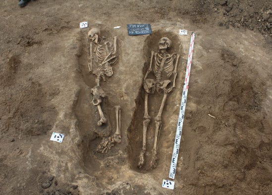
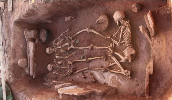
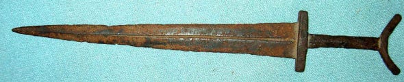
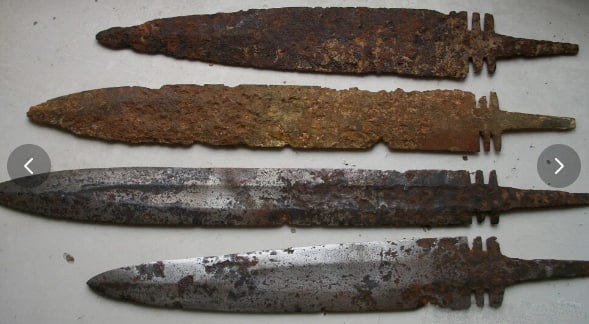
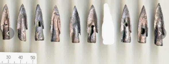
Certain superstitions and religious beliefs are wide spread throughout the world, and help the Archaeologist determine the ancient past. One is the idea that the dead are “going somewhere” and that they need some tools and amenities to help them on their journey. Some cultures burn their dead, some throw them in the river or the sea, some set them adrift in a boat that then is lighted on fire. The ones that are buried in the ground have the greatest story to tell. You can’t discover much if you find only the bones.
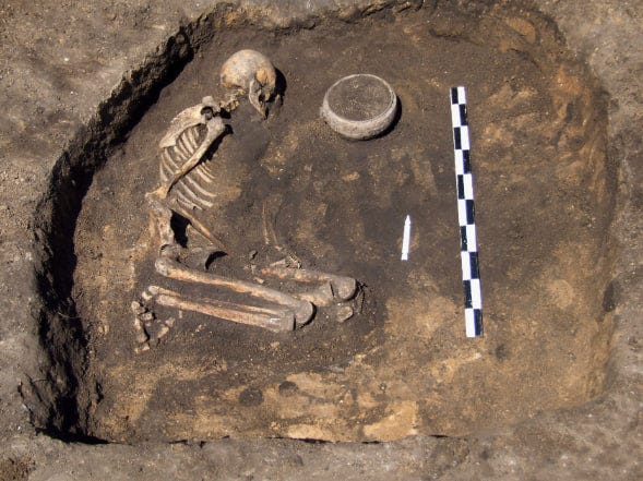
This guy had a pot.
Here’s the wife
And the children. What gave this family an honored burial?
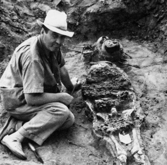
Lev Gumilev

Pottery is identifiable by approximate date and by zone of use. Not a perfect reflection, because pottery is traded and has a wider range than the people who made it.
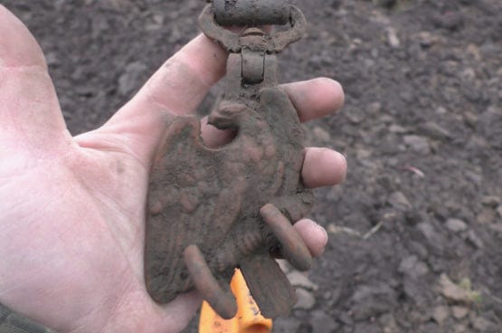
Some kind of a buckle.
These are in burials
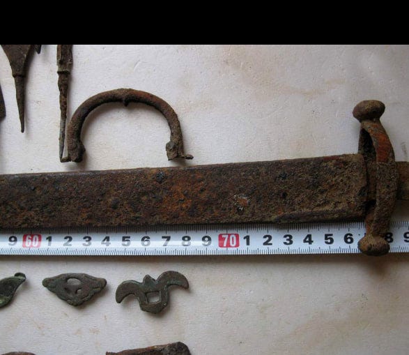
There are tons of images from Khazar graves on the Inernet.
You can see that these finds prove a lot of information about past civilizations.
This is a map of where these finds are located and is also on the INDEX page, so you can open it in two places, watching for the location while you read the key.
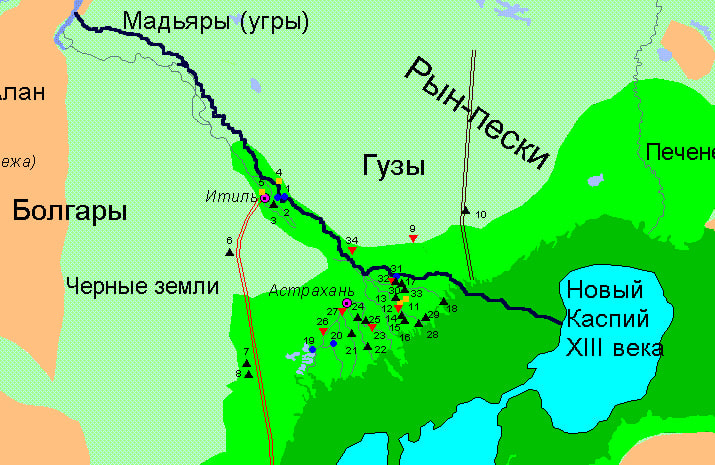
I forgot to add: Dark Green are the lands flooded in the 9th and 10th centuries. Light Green lands flooded in the 13th and 14th centuries. (You see why Khazaria was forced out of their lands.) Blue is the shoreline from the 9th to 11th centuries. The Dark Black line was the main river channel in the 6th century. the Akhtuba. The double Red was Khan’s road. The double Black is a caravan trail. The symbols are the origin of the finds, Guz, Turkic, Samatians, Tartars.
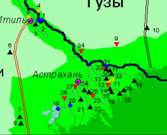
Legend to the map of Volzhskaya Khazariya
1. The ruins of Saray Batu Khan.
2. In the floodplain of the Volga - Akhguba, on the right bank of Astuba in the tract Central and near the poultry farm (against villages of Selitryany) found on a plowed field fragments of red, well-burned ceramics, made on a pottery circle. Ceramics similar to finds in Saray and her affiliation Tatars of the XIII-XVI centuries. no doubt.
3. On the dried shore of Akhtuba below the mouth of the duct Mangut found fragments of cake, bad scorched, with brown surfaces and black clay in the middle. Ceramics of this type are known from Don to Baikal and dates from the VII-XI centuries .; in this case it can be with the greatest degree of confidence ascribe the guzam. One shard found in situ in layer under alluvial deposits with a power of 1.4 m.
4. On a hill near the southern outskirts of the village of Basta Sarmatian burials inflated by the wind.
5. Near the southern outskirts of Enotaevsk, in a landslide coastal hill over the Volga, were spotted human bones protruding from the earth. Man lay on his back with his head east, on the right the side was a poorly preserved iron sword. B heads - clay pot, right elbow - clay cup (sarmat).
6. At the side of the road, lying, as you might think, along the old caravan path east of Sarpinsky lakes, several found fragments of ceramics: gray-clay, good scorched, unorthodox. Despite little expressiveness, they resemble seroglin ceramics of Khazar burial sites on the tubercle of Stepan Razin.
7. Several found at the side of the road fragments of ceramics similar to Khazar gray-clay vessels of the tubercle Stepan Razin. Findings discovered during reconnaissance in 1960.
8. On a hillside, near a small lake, several fragments of ceramics found, similar to Khazar.
9. Azau tract - sand steppe overgrown rare bushes and tamarisk cups. Nearly in each purge on the mainland the bastard could find fragments of ceramics type attributed to us to the guz.
10. Punished trail through the market sands goes straight to the north. Now she lies next to her road. The finds were made in a bogey basin near an abandoned well. A lot of ceramics of Tatar and Guz, as well as fragments attributed by M.I. Artamonov to the bronze age. But the last is not of interest to our topic, and their description is omitted.
eleven. Grave digger Stepan Razin.
12. The system of tuber between the ducts Tas and Kabchik (Tarnaya). On the Biling tubercle (abs. Father peaks minus 14.4 m) burials detected (abs. ppm - minus 16.1 m). The skeleton is oriented to the northwest, lies on his back, his hands are extended, his head is tilted to the right. The skull is crushed, the bones are very bad safety. Around the skeleton two clusters fragments of ceramics: at the right knee - leftovers a vessel of seroglin, stucco, with drawn trellis of corrugation, whisk with roller on the inside; at the head - light brown with coated black surface, a leftist resembling a guz. Near the skull - piece of iron knife. A meter to the right knee - funeral pot, modeling reddish-brown, a whisk without a roller. Dimensions; height - 4.5 cm, neck width - 3.0 cm, width mid 5.0 cm. At the right elbow clay yarn, and the right side has an iron awl. On the chest - bronze round mirror with handle and button in center; mirror diameter - 5 cm; handle length - 1.2 cm; in a round hole in the handle. On the left shoulder, the right elbow and bronze fibula on the chest. Lower part, where the needle is fixed, wrapped in wire, the middle part is lyro-shaped with thickenings and a button at the end. Halat or dresses (fragments of the tissue of it stick to the ground) is indicated beads - 13 whole and 9 debris. Glass beads, round, from pipe segments, covered with a layer iris that hides color. One is bead heartbreaker. Date beads (as defined Z.A. Lviv) - I-II centuries. AD.
Biling Drilling Lifting Material varied: near the Muslim cemetery - Tatar ceramics of the 15th-16th centuries; west of burial many fragments of stucco ceramics similar described during the skeleton. Many fragments of iron products: knives, dodged, fragment of the sword. The largest the number of finds is associated with the spots of the compressed (beaten) land (floors where there was housing).
East of the above burial discovered another one, head to north, very poor safety in the solid layer cemented soup covering in places bones by 5 cm. Accompanied by fragments gray-clay stucco ceramics, small and inexpressive. No things with a skeleton discovered. Lifting material - debris (up to 2 cm) iron guns randomly scattered across the surface of the tubercle.
13. Bugor Kazeny. Discovered in a crest central booger skeleton is very bad safety. The skull was broken and its remains lying around the skeleton. Saved ribs and kneecaps made it possible to establish that the skeleton lay on his back and was focused to the west. Near the skeleton of the left side was bead of bulk land 0.2m higher than skeleton. Under her lay the lower jaw of the horse on a layer of charred soil. 1.5 m southwest lay fragments broken, black, burnt vessel and horse teeth. Accompanying things: a fragment of an iron knife under the skeleton neck, pieces of iron slag and copper plates up to 1 mm long and ash mixed with sand.
Here and everywhere further the burial ground, sometimes sprinkled with eol sand and dust.
Lifting material - ceramic fragments: 1 ) black-lin ceramics, molded with ducked furrows; 2 ) pottery, black with burnt to red-brown surfaces; 3 ) pottery ceramics, good tortured clay with gloss; 4 ) the same without gloss, roller with roller; 5 ) same with reddish inner surface; 6 ) slap neck elbows; 7 ) red clay ceramics, pottery, tile ringing; 8 ) iron fragment records.
Burial: over the cliff of the northern edge of the tubercle in its central part (in the middle) was discovered western-oriented burial is good preserved due to the fact that the layer cemented over the skull reached 7-10 see. Only the crowns of the two vessels protruded outside. The skeleton lay on his back with his stomach crossed hands and feet slightly bent in the knees. There are no legs and hands. In the head there were bones and the skull of a ram, and a little higher - fragments of a thin copper plate with holes and rivet around which the remains are preserved strap. In place of the brush of the left hand - partially preserved bronze mirror 2R =6.8 cm, 0.2 cm thick; below the pelvis is a piece of iron knife; the other, the larger - on the left shoulder. These are the wreckage one knife 12.7 cm long, 0.7 cm wide, single-use. Obviously, the knife was broken when burial and debris were in different places.
At the head of the head - two gray-clay vessels, lep, flat bottom, 14.5 cm high, with diameters 11 and 11.5 cm. The crowns are bent out, on one - the pit ornament. The legs of the skeleton were covered more than head, H backfills -25 cm, and on it 40 cm crushed north of the skeleton flat-bottomed cannon similar to described above, and a few amorphous bones. Attitude of this. third pot to burial unclear.
The second burial on the same tubercle, but lower than previous; also oriented west. The skeleton is laid on the back, the arms and legs are extended, feet are absent, bones of the hands mixed up due to a small landslide, who covered the body and thereby saved it from destruction. Long-distance bones there were large gaps. Not affected by landslide the skull remained on the surface and was crushed. C on the right side of the skull stood a black-headed stucco pot with a corolla bent outward and decorated a fancy ornament. Near him were fragments of crushed red pottery, a well-burned vessel, and above the head - fragment of a single-use knife.
14. Bugor Koren. Found in the center of the tubercle burial is very poor, oriented to the northwest. Accompanied piece of iron knife and fragments brown-gray, stucco ceramics with fossa and furrowed ornamentation. Lifting material: 1) black ceramics, well-burned, pottery layer; 2) the ceramics are stucco, coarse, black with burnt sides - guz; 3) black ceramics, stucco, poorly scorched with a flat crown; 4) red clay ceramics, pottery with a flat crown, with furrowed ornament.
East tubercle Koren - a low Bai-bugor, literally sown with finds down to the shards water dandies of the XVIII century. Lifting material collected: fragments of ceramics made of well-wrapped gray dough, snap, pottery, walls almost flat, apparently from large vessels with a lattice or parallel stripes. Roller Wens bent out; flat bottom, sometimes with a ledge outward, with traces of the board. The pens are flat, oval.
15. Bugor Kungur. Lifting material - fragments seroglin ceramics and iron guns.
16. Bugor Beshlyk - some fragments of ceramics and iron, there are bones of people.
Lifting material: 1) fragments of red clay ceramics with furrows; 2) fragments of guz ceramics with a wreath cut off; 3) ceramics black, poorly burned with dimples and furrow ornament; 4) ceramics brown gray (see. Root); 5) ceramics with drawn by the gloss (see. Bai-bugor).
17. Bugor Shike Hill.
On the east side of the hill, above the slope row dugouts with access to the east, with blurry walls. These are relatively late buildings. On the top of the tubercle the remains of the burial - the ribs and the trace tibia heads to determine, that the skeleton was oriented north. Accompanied by fragments of gray pottery ceramics with brown surfaces and debris iron guns. On the crest of the tubercle squares rammed land, without vegetation. Apparently, the floors of ancient dugouts.
18. In the sea, according to the Igolkin Bank, a excavator dug a channel to deepen the fairway (channel). Along the channel of the distillation tubercle, for the sea is deep here 0.5-0.8 m. On one of the miscarriages against the island Far discovered animal bones and fragments ceramics rolled with water. Large vessels black, with red roasting surface, the dough is weak, poorly exhausted, dents from fingers. Small vessels are black, with red surface from roasting, the dough is weak, poorly tortured, dents from the fingers. Small vessels are gray-clay, thin-walled. Those and others similar to previously found Khazar. Absolute find mark - minus 29.6 m, taking into account sea level in the bank and channel depth.
19. "Damn settlement", or "Motherland Books of the Big Drawing".
20. Bakhtemir and Old Coast Survey The Volga did not give a hike. Decent Barov tubercles built up, and distant ones contain a few fragments of Tatar ceramics. Bottom - alluvial plain, with crowds of willows and thickets reed. Above, at the latitude of the Devil's Town Hill", tubercle Karakol (7 km southeast of der. Self-deals) - an unsupported Tatar settlement. Traces of the hollow, fragments of large red clay vessels with furrow ornaments: furnace residues from bricks; between bricks bones of a bull and red fish.
21. Near the village of Uvara, a group of tubercles, where, by survey information, "skulls and shards". Tutinsky tubercle examined, where managed to clean up the remains of three Khazar (i.e. similar to the hikes of Stepan Razin) burial. All of them are ground, in very hard cemented soup, poor preservation, so how blurry.
a ) Crushing: skeleton residues - spine SHS oriented ( 3450 ); two pots (fragments): 1 ) red clay pot, good burnt flat bottom, stucco, bottom diameter 9.0 cm and 2 ) scraps of stucco, black, with red from wall firing, no bottom, diameter 20 cm; inside "lunch" lamb shoulder blade, amorphous bones, scrap of iron and ash.
b ) Burial: skeleton without head, without left hand and left legs; oriented northwest.
in ) The vessel is crushed, so clay bundled. Black clay cake pot with caught surface, the corolla is bent out, the bottom flat.
22. On Tabola, at the Chapaevsky fish factory, examined two tubercles, the first from the river a fragment of a vessel made of glued clay ribbons found (fried), similar to Dagestan vessels from under the Derbent Wall VI c. On top of the tubercle collected lifting material: 10 fragments Khazaras time seroglin ceramics, 5 fragments of guz ceramics and the bulk - pottery seroglin ceramics, ringing; ornated with furrows and pits, crushed by the oval end of the stick.
On a tubercle 1.5 km away from the river, gray-clay pottery, strong ceramics with a round roller on the little one. Decorated by a number of quadrangles indentations made by a wand along the corolla. She is close to Khazar, but not completely identical, maybe because we meet there are fragments of large vessels. On the examined tubercles found spots of round and oval floors dwellings.
23. On Tabola, near the village of Semibugra (them really seven), a tubercle examined - Sarai Tube. Discovered varied ceramics: gray elk; black with trailing drawn by a grate; red with furrow ornament and stucco, black in breaking with red burn (guz). Number of finds (45 fragments) exceeds all previously examined places.
24. On the Tobol duct, near the village of Razdor, chain Baer's tubercles. Ceramics are the same for everyone - three types: a) red, pottery, good burnt; 2) thick-walled, stucco, with red glutton, black dough in scrap (guz); black, popped, well-wrapped dough, ringing shards.
25. The baraniy tuber lone above Tuzuklei among the delta plain 1 km from the river. Abs. - minus 14.4 m. Affects the abundance of lifting material and burials.
Findings: a pot with a lid is collected from shards. Height 10 cm, diameter on the corolla - 8.5 cm, length - 7.0 cm, and the middle part - 12.6 cm. Stucco, black-clay, the corolla is bent out.
Skeleton of a child, lies head to the east. (It is - the only case of oriental (south) orientation.) Lies on his back, skull crushed, arms and legs pulled out. In the head of the head, in the place where usually the bones of the sacrificial ram are located, there is a skeleton baby. Sucked skull the baby is on the right shoulder of the skeleton. Near the head of the skeleton - two pots. One black, stucco, with a gray surface and a wreath bent out; his outside covered with horizontal grooves, height - 1.5 cm, diameter - 12.5 cm, wall thickness - 0.6 cm; second - flat, red, pottery, pear-shaped molds with a flat handle, well-fried dough; height - 12.6 cm, diameter - 10 cm; wall thickness - 0.5 cm; on a wide part - two fingers of stripes, in the base of the neck is one, and a pattern is drawn over it the form of the festoons. Under the skull found 1.3 cm diameter ring earrings.
Skeleton of a child at the northwest end of the tubercle lies on his back, head to the west. At the right temple fragment of the bronze earring-ring. Narushna left side of the ribs and collarbone: they lie on the skull and around him. A vessel assembled from shards, stucco, corrugated. Partially restored. Height - 12 cm; diameter - about 14 cm.
Skeleton of a child without pots, runs on the right side oriented west. The skull is broken in recent time; under the skull is an iron needle, under pelvic bones and lower back traces of wood, like gaskets. Skeleton length - 0.60 m.
Lifting material on Baranya boogre: a) guz ceramics - 13 fragments from the walls vessels, inexpressive, with a strikethrough nail horizontal grooves; 6) ceramics Tatar - 2 fragments; c) Khazar ceramics, made on a circle, gray-clay, ringing - 4 fragment.
Ornament: 1) wave (sinusoid) of seven parallel furrows; stroke width - 2 mm; 2) the same, heavier, stroke width - 4 mm; 3) grooves straight, four in the middle of the side of the vessel; width bar - 4 mm; 4) the same, deeper, covering the entire fragment of the vessel; stroke width - 2 mm; d) Khazar ceramics, stucco, black, weak scorched; e) two fragments of an iron knife; e) fragment of ceramic tiles - tiles, slightly curved; dimensions - 13x7x3 cm. On the north and quadrangular spots of slain land that are apparently, are the floors of the dwellings. Burials are grouped on the southern part of the tubercle, between the crest and sk.yun and on the western end of the tubercle.
26. Found on a baroque tuber on the shore of Khurdun two inexpressive fragments of the guz ceramics.
27. Lifting material - guz ceramics - on Mullin's tubercle.
28. Lifting material - ceramics - on the tubercle Tishkovsky (Tishko in the lower reaches of Buyansky duct, close to the sea): a) fragments of ceramics gray-clay, with black surfaces made on the potter's circle, with a drawn catch - 3 fragment (hazaras); b) guz - 3 fragments; c) seroglin, stucco with inner red surface.
29. On the left bank of the Buyan Stream, on single tubercle in delta alluvial plain - two inexpressive fragments Khazar ceramics testifying to the population of the southern delta in the first millennium n.e.
30. Lifting material - ceramics - on Fedoritkin tubercle near the village of Multanovo. Carbonated vessels from a tormented test, outer surface with drawn gloss, walls flat, roller with roller, ornament furry. A lot of wreckage of iron guns.
31. Lifting material - Tatar ceramics - on boogre against the village of Kotyaevka, on the right bank Kigacha.
32. Lifting material - ceramics - Unnamed tubercle, near Tumganovka: a ) seroglin ceramics, pottery, well-clipped, the corolla is round, bent inside. There are no analogues in our finds is dating.
Naryn-Gora Bugra on the Makarka River: fragments Khazar red ceramics and fragment - gray.
33. Thief-bugor, near the Red Yar: a ) ceramics gray-clay, pottery, with black surface, the wreath is bent out, burned the good, drawn gloss - II fragments ( analogy - Saltovo, Khazars ); 6 ) seroglin ceramics, stucco, well-lipped; 4 fragments ( hazaras ); in ) red clay ceramics, pottery, good scorched - 9 fragments ( Tatars ); g ) fragments iron guns - 8 fragments.
Guard tubercle near Krasnaya Yar: a) ceramics, gray, well-burned, porous with a tuberous surface - 2 fragments; b) a handle from a jug, stucked, light red, good burned. Zurmansky tubercle near Krasnaya Yar: a) one fragment of ceramics of seroglin ladder (Khazar); b) two fragments of Tatar ceramics.
Boogers from Red Yar to Marfin - no finds.
34. Small Aral - tubercles east of the village. Lifting material: red and gray ceramics, good scorched (2 fragments) and guz, amorphous (2 fragment).
p86
.
Great storytelling.