


2. discovering Khazaria, journey into a wide space.
The broader the goal, the easier it is to hit it, but what do you do if you need to get to a certain point? My task was not only to visit Khazaria, but also to prove that it was indeed Khazaria;

There are two great stories in this chapter. The first is a diary of an expedition in four directions looking for Khazar remains. The second is in the report to the Geographical Society after the expedition. “Archaeologists are not interested at all in what seemed to me the most valuable - landscape observations.” It seemed to them simply geographical fiction, and the thoughts about climate change in historical times is - popular science fiction. That is why A.A. Aleksin and I staged a joint report at the Department of Ethnography of the Geographical Society, [78-79] where the audience consisted of representatives of different specialties. 1960 or 1961
Gumiev explains history with climate change. If rains dry up, it doesn’t mean that they disappear from the face of the earth. Not at all, they move to a different location effecting a different people. In Gumilev’s theory tropical cyclones move in century long patterns in three basic directions. If they are falling on the upper Volga catchment basin, the river is a torrent and the Caspian Sea rises, flooding great lands. If they move out onto the central Asian Steppe, the desert turns to pasture and the nomads expand there activity. If the cyclones move north, both the steppe and Eastern Europe are dry, but the northern regions are developed and the northern Arctic sea routes open. He supports and illustrates his theory with the record of Asian and European peoples, which is also a way to give the dates to climate changes.
I find it fascinating.
________________
In the expedition, I [64-65] had to find monuments convincing enough for my skeptical colleagues. Not yet being able to completely renounce the classical methodology of archaeological reconnaissance, I assumed that I would come across a place where Khazar burials or settlements would turn out to be. As it turned out after two months, I was right and I was wrong.
On August 18, 1960 A.A. Aleksin welcomed me in Astrakhan and a new expedition began. This time the field equipment was simply superb. We had a leveler and maps, a tent and sleeping bags with cots, a car with a chauffeur Fedotych and a primus with a cook Klava. And for traveling along the delta channels, we had a wonderful motorboat. Its captain, Mikhail Alexandrovich Shuvarin, who took part in the expedition's work to the end, deserved our sincere gratitude for his precision, resourcefulness and diligence, as well as for his sympathy for our work. The expedition's success owes much to his knowledge of the labyrinth of the delta channels.
А. A. Aleksin offered, instead of a detailed search in one place, to conduct a broad reconnaissance of the entire area, where the Khazar monuments could be. There was an element of risk in this plan. If this time the expedition returned without findings, but only with observations, we could not count on a third trip. Nevertheless, we took the risk, setting out four routes: south, to the delta to the sea; north, along the bank of the Volga to Saratov; west, to the Kalmyk steppes, and east, to the Ryn-sands, in order to survey the area that had dried up in recent years due to the retreat and shallowing of the Caspian Sea. It was hoped that Khazar monuments could be found in this wide area.
1 These turned out to be the graves of Muslim mullahs on the outcrops of underground gas, set on fire by believing Kazakhs. The inscriptions on the graves, made in clear Arabic script, gave the exact date - the beginning of the XX century.
2 And I said the following: "Oh, Mikhail Illarionovich! When Schliemann searched for Troy, based on Homer's descriptions, he was on the right track. But he had an exhaustive and reliable source, even though it was written in hexameters, not academic scholarly stamps. And what do we have at our disposal? Only a heap of contradictory references, most of which look very serious, but on closer inspection turn out to be the processing of hearsay and ancient gossip into a form befitting the science of the day. Let me start the search again from the other end. We shall encircle Khazaria from all sides and tighten the ring of encirclement until the prey is in our hands. There is no need for costly expeditions. Let me alone with a travel diary and compass, and for the rest we will rely on the fact that hypotheses are sometimes confirmed."
p30
Delta
The first feeling a traveler experiences when getting from the dry steppes of Astrakhan Region to any of the numerous channels of the Volga Delta is surprise. It is hard even to imagine how different these geographic areas are from each other.
When you go down from Astrakhan, at first green meadows spread out on both sides of the channel, but soon chains of willow thickets appear on the banks, gently rustling with silver leaves. Below these are replaced by walls of high [65-66] reeds1 or thickets of chakan, resembling ancient swords, with their tips raised to the sky. And in the evening, the sun sinks in the transparent smoothness of the channels, and it seems that the whole thickness of the water is pierced by the purple rays of the sunset.
The landscape is alive. Every now and then splashing big fish. Attentive herons stand in shallow water near the shores. Flocks of ducks swim in the backwaters. Sometimes in the reeds you can hear the rustle of the wild boar, the only animal for which the thickets are not an obstacle. Elongated mounds of Baer knolls, (elongated ridges) rise above all this charm, and small islands of the true semi-desert with thorny tumbleweed bushes sit on the dry tops.
On the slopes of the hills and elevations are settlements of Russians and Kazakhs. These two peoples have long lived together, respect each other, go fishing together, and graze herds of cows and horses on flood meadows. Involuntarily it begs the question - isn't that how the Khazars lived in ancient times? After all, in these places, there is no other way of life. But we needed finds.
Mounds of mounds on the Bushma river really resembled an ancient burial ground, but, as it turned out after finding out by piercing, they were just ditches from the river bed when deepening the waterway. On Sizom Bugrad2, near the village of Zelengi we came across a Kazakh cemetery. The deep grave-pits were not backfilled, but covered with planks and straw and enclosed with an earthen fence. But this fact would be of interest to an ethnographer rather than an archaeologist.
The inscriptions on the monuments, made in Arabic script in exceptionally clear handwriting, gave the exact dates of the burials, namely XX century AD.
We drove out to sea through Belen Bank, and our eyes opened flat islands and knee-deep water. Birds bathed then in warm fresh water, then in the rays of the dazzling sun. Fish left silvery, instantly disappearing tracks among the seaweed. We walked the ancient land of Khazaria 28-29 m below the level of the world's outer ocean3, but there were no finds, and where to look for them - it was unknown. [66-67]
On the way back we drove up to a tiny village nestled on the slope of Stepan Razin's hillock. A friendly Kazakh came out to meet us and, with a smile, invited guests into the house. We had tea, slept over, and in the morning, we went to look at the top of the hill, decorated with a high triangulation point. And here we were rewarded for all the excitement, mosquito bites, and fruitless trails over empty knolls. A small brickyard had been built under the eastern slope of the knoll. The clay was mined by shaving the tip of the knoll. So by our arrival there was a steep precipice 20 meters high. When I looked down, I saw the remains of human bones sticking out of the cliff. I had my archeological knife with me and I immediately began to clear it. My companion A. A. Aleksin and our kind hosts brought a shovel, quickly made a broom and, I do not remember how much time later (I did not notice or count it), we saw the skeleton of a man lying on his back. There was a small iron knife at his right thigh, an earring - a bronze ring - in place of his left ear, and in the headboard a magnificent vessel with fluting and glossing, unlike any known so far. The feet were cut by a precipice.
The boundaries of the burial time were accurate: the iron knife ruled out even the Bronze Age, not to mention the Neolithic; the Tatar burial rite is well known and quite different from the one we found, so the upper date would be the 13th century AD, and in the Volga delta [67-68] at this time lived Khazars. Vessel by the nature of manufacturing should be dated to VII-IX c., but rather, just the VIII century, because related to the same genus, although different in details, vessels repeatedly found on the Don4 and their dating is not subject to doubt. So, we have in our hands Khazar skull and there was no room for doubt.
The rest of the way to Astrakhan I spent as if in a fog. No matter what promised and no matter how deceived the rest of the time given to us, failure was now out of the question. Hazarin was found.
1 This is how the reeds are called here.
2 In the Volga delta each hillock has its own name.
3 Some depressions of the Asian continent lie below the outer world sea level, taken as zero. Therefore, the altitudes of the topography here are marked with a minus sign.
4 The so-called Saltov culture [see: 7, p. 35, cited literature].
p31
Steppes
Having finished our excursion in the delta, we moved to a car and went to the steppes. Three roads were ahead of us. The first one went north, along the right bank of the Volga; this route was caused, actually, by the requirements of geology, but we wanted to determine on the way, if not the presence, at least the absence of the Khazar monuments in the territory, no doubt, which was part of the Khazar Kaganate. The second route, the southwestern route, passed through the Kalmyk steppes and the Black Earth to the shore of the Caspian Sea. The third route was planned to the east, into the semi-deserts and loose sands of the Trans-Volga region.
In order to accomplish such a large program in the only month - September - that remained at our disposal, we had to drive fast, but fast movement reduces the possibility of observation. After all, the purpose of the search were tiny fragments of earthenware, which had been dusty for a thousand years and almost merged with the soil. Usually, an archeologist walks on foot and looks under his feet, but here he had to guess the place of the search from the back of a fast-rushing car. There is no doubt that a lot of finds were missed, but we found a new method of searching, which later became the most effective way of research. By small, barely perceptible signs, we learned to guess the places where the Khazars and their contemporaries had stopped before us. There were times when the car would make its way through the yellow hot sand, with sand bumps up to half a meter high and covered with thorns on the sides. No desire to stop the car and [68-69] get off the ground. Suddenly, the road becomes flat, and at the edges of it are spread out flat areas of clay takyr, covered with a pattern of cracks. The chauffeur is ready to give the gas, but I almost intuitively stop the car, jump off and walk, tilting my head. Yes, there is a shard, then another, and soon a whole handful of remnants of the Middle Ages.
Again we drive on, and for a long, long time there is no desire to walk again, burying my nose in the ground. Now I know why the find was made there.
The flat clay ground, cracked from the heat, is the ancient bottom of a lake or a shallow river. Where there was fresh water, both caravans and shepherds stopped to rest. There they would carelessly break the pots and drop the shards that I was so diligently searching for. It seems simple, but I didn't realize it then, I only felt it.
There could be many such examples, but the principle remains the same. Reading the landscape, an almost tangible geographical phenomenon [44], proved to be the surest way of archaeological search. But we only learned how to do this on the long road, to the description of which it is time to return.
So, we drove north, and a few hours after Astrakhan left behind, the landscape began to speak. Up to Yenotaevka was the already familiar loamy steppe that dropped almost steeply to the blue surface of the Volga, which was undermining the shore.
On the other bank the floodplain was verdant, and I involuntarily remembered the words from the letter of the Khazar king Joseph: "The country (ours) does not receive much rain. It has many rivers in which there is a lot of fish. There are (also) many springs in it. The country is fertile and plentiful, consisting of fields, gardens, and parks. They are all irrigated from the rivers... I live within the island. My fields, vineyards, gardens, and parks are inside the island”. [50, с. 87]. How accurately the description was made! The green floodplain, similar in landscape to the delta, the island is not only because it is washed by two powerful channels - the Volga and Akhtuba, but also because it is a piece of fertile land among the vastness of the steppes, suitable only for nomads. And in Arabic medieval literature, the word "island" was also applied to groves among the steppes (as we say, "islets of forest") and to any limited space. King Joseph may have used the word in both senses. [69-70]
North of Volgograd the terrain began to change; the Volga flowed in a single powerful stream, the smooth steppe was swollen with gentle hills and cut through deep, forested ravines. Even the air had changed: it had become damp and harsh; jagged clouds floated in the blue dome of the sky. There was no doubt that we were in another country. And rightly so. In Khazar times the mysterious Burtasians and belligerent Ugrians, ancestors of the Hungarians, the sworn enemies of the Khazars, roamed here. One may believe that the Khazar Khans and kings of the formidable force of their hired troops kept this area in relative submission, but people accustomed to the mild, even somewhat spicy nature of the delta, this hilly, relatively cold country must have seemed alien. At each point, stopping specifically at the creeks, in the valleys, on the passes over the hills, I carefully searched for Khazar ceramics, but did not encounter a single shard. There was no reason to go further. From Saratov we turned southwest and returned to the Kalmyk steppe to the shores of the Sarpin Lakes.
This route was not chosen by chance. In the heat of scientific polemics with M.I.Artamonov, Academician B.A.Rybakov suggested that this was the location of the capital of the Khazars, "a half-wild, predatory, steppe, tribe" [72]. [72, с. 131]. On the map this thesis looked convincing, but enough was to visit the place to remove all doubts: there was not and could not be a Khazar capital here.
p32
Today, the Sarpin lakes are shallow puddles, overgrown with reeds, but even when the climate was wetter and the lakes were wider and deeper, they remained waterlogged lowlands, without solid banks, whose contours changed from spring to fall. A small population could still make a living in this area, but no one would build a city here. Indeed, in the low greenery of the meadows between the lakes we did not find city ramparts, but neither fragments of dishes, despite the long stop before the further way to the south.
Three roads lead to the shores of the Caspian Sea: the western one runs along the high part of Kalmykia, through an area with absolute elevations above the level of the ocean. There are chains of high Bronze Age burial mounds that have no relation to the Khazars; the eastern one runs close to the shore of the Volga, and if there was anything of interest there, it would have been discovered by Astrakhan archaeologists. We chose the middle, most direct road, the northern end of which rests on the bank of the Volga near the village of Vladimirskoye, 25 km [70-71] south of Yenotaevka. It seemed logical to me that the road, most likely, would go on the line of the ancient caravan route, and it was from this point on the right bank of the Volga every spring left the Khazar Khan caravan, accompanying him to the southern green meadows on the banks of the river Ug-ru. If this assumption is correct, then, I thought, on the sides of the road we will find traces of pottery Khazar time. Let them be small, the old and new roads may not coincide throughout, but in the vast steppe is at least some reference point. Indeed, after a day's journey south of the Sarpin Lakes, we found the first placer of fragments of medieval pre-Tatar ceramics. The pottery was small, poor, "not expressive," as archaeologists say; but until now there was nothing.
From that moment on, the road came alive for us. It meandered through sand overgrown with dry thorns, among gentle hills that couldn't even be called hills. To the south, oblong puddles of salt water began to appear, framed by liquid, salty, surprisingly caustic mud. This began the "area of the sub-steppe ilmens," traces of the retreat of the Caspian Sea.
Long ago, at the dawn of human culture, about 15 thousand years B.C., when the waters of the last melting glacier flowed through the Volga River bed, the Caspian Sea contained them. Its level rose to an absolute mark of plus one meter or so, i.e. 29-30 meters above its present level. But when the dry xerothermic epoch came, the sea began to recede. The evaporation mirror was huge, the depths in the flooded area were negligible, and the water under the scorching sun turned to steam. The sea receded, lingering in the hollows that became salt lakes. This is how the "area of the sub-steppe ilmens" developed by man in the Upper Paleolithic period came into being.
On the shore of one of these salt lakes we discovered a find that left me indifferent, but greatly interested my companion. There were flint flakes, shattered bones, and several irregularly shaped slates about 0.5 cm thick. It was a typical Paleolithic site, not remarkable at all, except that the shale slabs were, according to the geological definition of A. A. Aleksin, brought from the Caucasus Range.
The picture was clear. People followed the retreating sea, finding food in small lakes: fish, mollusks, crayfish and waterfowl eggs. The material we found was so [71-72] unimpressive that it was impossible to specify the date of the retreat of the sea, but it was important that the Caspian Sea waters stood so high only in the Paleolithic era, and not at all in the historical period that interests us. Similar findings were made by us two more times, but they added nothing to the first conclusion, important only for the quaternary geologist, not for the historian of the Middle Ages.
South of the area of sub-steppe ilmens stretches a wide plain, the so-called "Black Earths". This is the bottom of the Caspian Sea, which dried up in the prehistoric period. From the west it is bounded by the spurs of the Kalmyk steppe, from the east it smoothly passes into the Caspian Sea. Even the coastline is difficult to determine, as it depends on the wind direction. The western wind chases away the water, exposing the bottom, the eastern one brings huge masses of water, flooding the coast for sometimes a dozen kilometers inland.
The name "Black Lands" was given to this gloomy plain because there is very little snowfall in winter, which mixes with fine dust and sand. However, it is during the winter that sheep from Dagestan and Kalmykia are brought here to graze. Ryegrass and white wormwood, which grow in this undulating steppe, are the best fodder for sheep, and the small amount of snow does not hinder grazing. At this time the plain comes alive, but not for long. The summer sun burns the uneaten grass of the sheep and the area turns into a desert; then, in the fall, the rains come, flooding the lowlands and turning the roads into mudflows. After the rains, the steppe is revived, and in September the sheep fatten up again for the hard winter.
Without the Black Lands and the adjoining Nogai steppes, it would have been difficult to imagine the economy of the Caspian cattleman in any era, but the lack of fresh water sources caused the absence of settlements here, and thus the lack of burial grounds, because the close people were buried near their homes rather than in a foreign land, even if it had been developed for cattle-breeding. From the point of view of an archaeologist, the Black Lands were a desert, very useful, but unsuitable for permanent human habitation.
p33
We were driving in early autumn and acutely felt the absolute desolation, the complete absence of life. Only near the road, two finds of pottery from the Khazar time showed that even a thousand years ago, people passed through this plain. But the fact that they did not live in these places was obvious. [72-73]
There was nothing further to look for. We could not reach the Terek and we turned back to Astrakhan, now firmly knowing that even if the Khazars owned the plains of the Northwest Caspian Sea, then they lived in other places, more welcoming and comfortable.
Desert
On a cool but clear September morning, our car quickly drove across the bridges of the Volga River channels and for some time raced along the familiar Akhtuba bank. Then it turned eastward, and we found ourselves among the wide plain of the eastern delta. How different it was from the central delta! A decrease in the amount of water carried by the Volga over the last century and a half has turned this area into a dry steppe. It is irrigated by the last undried channel, the Kigach, a mighty river, fringed with willows and reedbeds. Near Kigach, there are still green patches of meadows, but most of the plain is dry. Elongated lakes, remnants of the former channels of the Volga, turned into old riverbeds, are cut in between the gentle hills limiting this plain from the north. These lakes, called ilmens here, they are brackish because they stopped flowing long ago. But they were, and as proof of this, we found a large cluster of pottery on top of one of the Baer knolls. So the people who lived here had fresh water. The pottery was from two different periods. One part had archaic features and probably belonged to the Bronze Age, the second part was a familiar, rough, clay pottery made of black dough with sandstone, badly fired, so that only the surface of the vessel walls was calcined and browned, while the clay remained black in the middle. When viewed in broken form, this pottery appears to be three-layered, with an inner black interlayer. This is what a vessel burnt at the stake looks like. Such pottery is found in the Baikal region, Kazakhstan, Turkmenistan, and was even found on the Don during excavations of the Khazar fortress Sarkel. It can be clearly dated to the 7th-10th centuries, and its wide distribution points to cultural affinity of numerous Turkic tribes who were roaming at that time across the steppes of the Eurasian continent. In the 7th-10th centuries in the Trans-Volga steppes lived Oguzes, and therefore there was no doubt that we found their camp. [73-74]
In fact, this find was the first, sufficiently expressive and dated outside the Volga delta. It was followed by others. In the semi-desert adjacent to the delta plain, near the mud hills of the Azau tract, the Gooz ceramics became frequent. On this plateau, the blown-in sand is shallow, and the wind easily blows it up to the dark brown mainland soil, forming the so-called blowing pits. In almost every blowhole we found sometimes several shards of goose-water pots, and sometimes a whole cluster of them. Apparently, in the 7th-10th centuries this area was inhabited, which means that water was nearby. The only source could be the same old river, which is now dry, except for a few brackish puddles in its deepest parts. The conclusion suggests itself: in ancient times, or rather, in Khazar times, the channels of the Volga were not what we see now. Archaeology has brought us to the problem of the periods of formation of landscapes, to the establishment of their absolute physical and geographical dating, which is unattainable in any other way.
But we could not and did not want to linger on the obtained conclusion. Autumn was coming and we had not yet seen the famous Ryn-Sands. The day passed as we drove eastward along the smooth, rolling road at breakneck speed. Russian villages and Kazakh auls, which resemble each other in these places, flashed and disappeared. Obviously, the presence of a common material for [74-75] buildings and climate, creating the same living conditions for Russians and Kazakhs, forced local residents to develop a similar architectural style. I noted this for future works, because it is difficult to ponder when the cold oncoming wind is cutting into my face, piercing through, and there is nowhere to hide while sitting in an open car.
We were in a hurry, because in the crowded area along the tract we had no time to wait for finds, and there was so little time left! Finally, after spending the night in a cold tent, the car turned north from the village of Ganyushkin, and in the haze of dawn we saw high sand ridges topped with avenues of bizarre tamarisk bushes.
The wind died down, and the sand lay still, shimmering in the slanting sunlight with the shimmer of yellow and ashy pearls. Here and there bushes of dry grass rose above the sand-the desert lived and breathed. A caravan trail meandered beside our wide carriage track. It skirted the even small bumps, for the people who walked along it were saving the strength of their pack animals.
p34
One wanted to know who had built and maintained this path, and this question was immediately answered. Suddenly, among two ridges of high bardans on the left side of the road, a wide (about 100 m) and long (about 200 m) pit of blowing opened.
In its depth was a well - a pit with crumbling edges; probably no one had tried to get water from there for a long time. But around the well and all around the pit, shards were piled in great quantities. Here were familiar to us striped in a fracture "guza", red ringing "tatars", gray glossy "Sarmat", delicate thin-walled crocks from magnificently washed clay - the Bronze Age - and even glass shards of vodka corks XVIII century. The path confidently led to the well, and now became clear that people have walked on it in ancient times. Further the road went north, through the Kazakh village of Sazdy, where there was a second well, but there was not such an abundance of finds. There were isolated shards, while the rest had apparently been trampled into the ground by cattle herds.
We faced a new mystery: why people over the millennia preferred to drag from the empty shore of the Caspian Sea, this place is particularly shallow and canoe-able, instead of going up or down the beautiful Volga, where the road is better, and plenty of water, and where you can move along the river and shore.
The caravan [75-76] trail we found obviously led from the countries of Near Eastern culture - Iran, Khorezm - to the Great Perm (Biarmiya). The Scandinavian konungs married off their daughters to Biarmian chiefs, and even considered it an honor. Persian shahs received furs from there and paid for them with magnificent silver dishes, a tiny part of which has survived from the pernicious time and is stored in the Oriental Department of the State Hermitage [63,75, 76,84]. The way through the country of gooses was described by traveler of X century Ahmed ibn-Fadlan [49,66]. The road we traveled was either the same road or one of several that connected north and south. But why it ran in such a seemingly inconvenient place is another problem we had to solve.
The easiest decision we immediately made was to turn the car to the south and trace the road across the broad plain of the dried Caspian shore, in order to find there the remains of the port from which this path began. After a few hours' return journey we left Ryn-seski, crossed a narrow strip of road and adjacent fields. Soon the green meadows and reeds, twice as tall as a man, flashed in front of us. This plain had been covered by water 30 years before, but the sea level had dropped three meters, exposing the bottom. Here new surprises began!
At the bottom of the sea
Of course, the road, which had survived in the sparsely visited sands, could never have been as visible in the terrain that was rugged and cultivated. We thought the search would be difficult, and we were going to be guided by the finds of lifting material, that is, the same pottery lying on the surface of the ground.
But when we came down to the plain, we did not find a single shard. In vain did the car rush back and forth to the west and east, and in vain did I wander for hours with my eyes down in the ground. We looked over the huge area and found nothing. A new mystery arose (not much?): why did the nomads break their crockery only on high ground? This formulation of the problem was absurd, and we reconstructed it so why do we find pottery before the X century only at high places... Fortunately, we marked with a leveling course, tying to the nearest marks on the map, all the finds we made not lower than minus 18 m absolute [76-77] height. The answer to this could be twofold: either the level of the Caspian Sea in the first millennium was so high, or after the 10th century there was a transgression - the advance of the sea onto the land - which was later replaced by a regression - the retreat of the sea. Facts spoke against the first hypothesis. In 1,234, near Baku, a bastion was built, the foundation of which was at minus 32 m [3]. It was flooded later, and only now it rises from the water. But it was originally built on a dry place! So, the fluctuations of the level of the Caspian Sea, noted by geographers, occurred in historical times and it could not but affect the fate of the Caspian peoples. Isn't this the key to the "Khazar mystery"?
But the course of our thoughts and work was interrupted by a sudden adventure, which travelers do not need at all; I was so glad that we have so far managed without adventures!
At the time when A. A. Aleksin and I, stopping at a kilometer from the sea 2 cm deep in front of a dense wall of reeds, were mapping the data we had obtained, drawing sections of the pothole we had dug, and hoping that our chauffeur Fedotych, who had gone into the reeds with a shotgun, would bring some ducks for lunch, the floor of the tent became damp. We went out and saw that the reeds were slightly rattled by the southerly wind - seashells, and water was protruding from the ground everywhere. Literally before our eyes faintly visible depressions turned into wide puddles.
p35
Streams of water caught by the wind ran through the reeds. And Fedotych the chauffeur got carried away somewhere hunting, and we could not leave, leaving him.
We felt uncomfortable. We knew that a strong wind from the sea brings water up to 2 meters high. These "wind-surges" can often be the cause of the death of hunters or gaping shepherds. Fortunately, this time the wind was not strong, and we had time to fold up the tent, load the car and wait for Fedotych, who, when the water filled his heels, realized that in order to save his and our lives, we must spare the ducks. He appeared when the meadow around the car was covered with a mirror-like smoothness of water and, without wasting a minute, jumped into the cabin. Water did not scare us, but the worst thing was that the wet ground was turning into mud and the car could sink at any moment, and then our chances of publishing the results of the expedition were reduced to a minimum. Fedotych's skill was masterful to the point of virtuosity. The car waddled through puddles, skirted almost fantastically around deep places, climbed out of swamps, and even crossed a wide ravine, which we had not seen when we drove to [77-78] the sea on dry land, but which in these few hours had become a water barrier. At last we overtook the water, and the car went at its usual speed. I had reason enough to be convinced of the courage and endurance of my companions.
But at the same time there was a thought - how did the Khazars, who did not have all-terrain vehicles, flee from the surges of water? Of course, it is easier to get away from the water by horse than by car, because the horse will go where the car will get stuck, but it is difficult for sheep, and living under the eternal threat of flooding is somehow uncomfortable. Doesn't this mean that it is useless to look for sedentary settlements on flat shores, and hence for that port, for the remains of which we drove to the seabed. Obviously people were settled somehow in the Middle Ages, but how? And how unlike this dried up coast to the flowering meadows and thickets of the delta! If the Khazars lived around Stepan Razin's hillock, then the eastern plain was as unsightly to them as the western steppes.
Full of similar thoughts, I arrived in Astrakhan and bid farewell to my new friend A. A. Aleksin, having agreed that we would write an article about Khazaria together. He stayed for another month on the sun-drenched banks of the Volga, while I sought the rain drizzling over the Neva River, to make a new journey over the winter, this time not in space, but in time.
CHAPTER THREE, REPORT TO THE GEOGRAPHICAL SOCIETY
Now it was no longer a question of failure. On the contrary, the number of finds began to raise doubts among my colleagues. Evil tongues began to call the Khazar found a Tatar, but the vessel, which had been restored, and photographs of the burial in situ eliminated all doubt. Money for a new expedition was allocated without limitation.
Only one thing upset me: archaeologists are not interested at all in what seemed to me the most valuable - landscape observations. It seemed to them simply geographical fiction, and the thoughts about climate change in historical times - popular science fiction. That is why A.A. Aleksin and I staged a joint report at the Department of Ethnography of the Geographical Society, [78-79] where the audience consisted of representatives of different specialties.
The title of the report determines the nature of the audience. People come to the Society not on official duty, but after a hard day's work and only when they consider the topic to be really interesting and important. Therefore, the choice of a name is a very responsible thing, and it is possible to crash in front of the dock, which is always particularly annoying. After much hesitation we decided to call our report "Paleogeography of the Volga Khazaria and climate change during the historical period" and we succeeded.
In the hall of the Society's Council at the appointed time we saw many scientists1. First, we gave a summary of the observations made in the field season, and then posed the problem of the possibility of reconstructing the fluctuations of moisture of the steppe strip of the Eurasian continent for two thousand years and even more. For this purpose, it was necessary to combine the already described principle of heterochromous humidification of the polar, forest and steppe zones and the historical data on the movement of peoples living on the territory of the Soviet Union and the Mongolian People's Republic, involving the history of neighboring countries. Such a broad coverage could only be accomplished on the basis of the synchronistic method.
1 Doctor of Geographical Sciences A. V. Shnitnikov, Doctor of Physical Sciences N. A. Kozyrev, Doctor of Historical Sciences A. P. Okladnikov, Doctor of Biological Sciences M. I. Prokhorov, Director of the Main Geophysical Observatory M. I. Budyko, Director of the Geography and Economics Institute at the University A. I. Zubkov, and many candidates and non-candidates of various specialties. Presided S.I. Rudenko, under whose leadership in 1948 I had the honor to excavate the third Pazyryk barrow.
p36
In this case, changes in the level of the Caspian Sea could be used as a kind of barometer, indicating the trend of the steppe climate to humidification or drying up.
We proceeded from the following statement: the green steppe crossed by forested mountain ranges feeds huge herds of animals. The powerful nomadic peoples, the Huns, Turks, and Mongols, who perfected cattle breeding and became famous throughout the world, lived in this very steppe. The strength and glory of the nomads were directly proportional to the number of their livestock, which was determined by the pasture area and fodder reserves, and the latter depended on the rains that fell on the steppe. A decrease in precipitation led [78-79] to the advance of the desert to the north, an increase led the taiga to the south, and, in addition, the deep snow prevented animals from foraging in winter, which led to the mass starvation death of livestock (juts). It is difficult to say what was worse for the nomads.
Repeated attempts have been made to explain the conquering campaigns of Attila and Genghis Khan by the deterioration of natural conditions in the steppe. But these attempts failed, and for good reason. Successful nomadic wars and invasions into China, Iran, and Europe were carried out not by hordes of hungry people seeking shelter, but by disciplined, trained detachments relying on a rich rear.
Therefore, as a rule, these events coincided with the improvement of the climate in the steppe. The deterioration, however, was the reason for the eviction of nomads in small groups, usually settling in the steppe outskirts. Such ineffective movements fell out of sight of historians and geographers who paid attention to events of global significance, and hence a confusion arose in which the comparison of historical events and natural phenomena seemed meaningless. In fact, having established the two types of movements of nomadic peoples, we can compare them with the humidification of the steppe zone without any stretch. In this way, but with the reverse course of thought, we can reconstruct the changes in climate over those three thousand years, the history of which is known from written sources. This new approach to the facts is based on a synthesis of several sciences of geography, climatology, history, archaeology and ethnography. It has nothing in common with the "geographical determinism" of Montesquieu and L. Mechnikov, who reduced the explanation of historical events and the "spirit of nations" to geographical factors.
We establish only the elasticity of the boundaries of landscape zones depending on climatic fluctuations and consider the ethnic environment as an indicator responsive to changes in the external environment, i.e. nature.
Thanks to this approach, it was possible to establish that the space of the steppes, which served as an economic base for the nomadic economy, was shrinking, then increasing again, and the reason for this lies in the atmospheric phenomena, depending on the activity of the solar radiation.
Then we reconstructed the climate changes and level fluctuations in the internal basins of the Caspian Sea, Aral Sea and Balkhash and got a coherent picture, the first part of which I present here, because it has a direct [80-81] relation to the Khazar problem. Of course, this is not the text of the report, because much has been clarified over the past five years, but the principle of approach has stood the test of time and criticism of colleagues, as well as the form of presentation that we have chosen.
Historical and geographic panorama
During the warm and dry subboreal period, paleometallic cultures developed in southern Siberia [38, p. 53]. They developed on the border between taiga and steppe in the prehistoric period, but the onset of the cold period and the advance of the forest south undermined their economic opportunities, and their culture began to decline. On the other hand, for the inhabitants of the Mongolian steppe humidification and the appearance of forest islands were a blessing, and the steppe economy, both cattle breeding and hunting, in the middle of the first millennium AD entered a period of prosperity (Ibid. 118]. But in the second millennium A.D. this humidification in the southern regions of Central Asia ceased. The steppes dried up, the springs disappeared, the rivers turned into dry beds, and the river sands deposited at their bottoms became the property of the wind and turned into barchans, (dunes).
However, archaeological finds show that where there is now barren desert, a thousand years ago there were flourishing settlements, such as Hara-Khoto and the more ancient Shanshan, located on the dry riverbed of the Konche Darya near Lobnor. The rivers of Xinjiang are now lost in the sands, but their channels reach the Tarim River, which indicates their former abundant water, and the remains of villages along the banks of these dry channels give the opportunity to date this desiccation to the historical period [22, 26]. It is obvious that the desiccation was preceded by no less intensive wetting, also in relatively recent times, in the first centuries BC, when the Central Asian steppes were inhabited by the Huns. Nothing is more incorrect than the commonplace, very widespread opinion that the Xiongnu were a savage tribe, living off the robbery of the peaceful, industrious surrounding peoples. Like any people who have passed through the ages, the Xiongnu underwent a complex evolution, during which there were periods of peaceful flowering of culture, and periods of warfare, often defensive and sometimes offensive.
p37
The most difficult were the wars with the Han Empire, which sought to spread its dominance over the whole of Asia. The ratio of forces was not in favor of Huns, but they for 300 years [81-82] repulsed the enemy [26]. So there was something that balanced the forces, and the famous Chinese historian of the I century BC. Sima Qian believed that it was a nomadic way of life [14, vol. I, p. 93-96].
Nomadism developed in Central Asia at the beginning of the first millennium BC. [In the Hunnish time (III century BC - V century AD) it was on the rise. Technical progress was observed in everything. The original cart on stumps of tree trunks, which could move only with a team of oxen, was replaced by a cart on wheels. Instead of tents made of tree bark (chatras, whence came the Russian word - tent) there was a felt yurt, warm in the cold, cool in the heat, spacious and portable. The breed of horses was improved, and along with the small, hardy Siberian horse, the Huns bred tall, frisky horses very similar to the Arabian ones.
The Xiongnu dress - caftan and wide pants - was adopted by the Chinese and Romans, and in the 5th century Xiongnu hairstyles became the latest fashion cry in Constantinople. The Xiongnu economy was associated with the use of the forest-steppe landscape. They equally needed dry steppes, where cattle could get food in winter, and forested mountains. They used wood to make carts and yurt frames, as well as arrowheads. In addition, steppe eagles nested in the mountain forests, and their feathers were used as arrow tails. The copses served as shelter for livestock during storms and provided firewood for shepherds when the dung fuel was covered in snow. It was the presence of mountain ranges in Mongolia - Hangai, Hentei, Mongolian Altai - that influenced the character of the Xiongnu economy and thus the peculiarity of the Xiongnu culture.
But the described combination of landscapes depends not only on the relief, but also on the degree of moisture. Long-term droughts reduce the area of mountain forests, as well as the area of steppes, then stony deserts grow, where life disappears. Then the population shrinks and the nomadic powers declines. This phenomenon can be observed by tracing the history of the Xiongnu. In the 4th-1st centuries B.C. Huns lived on the slopes of the Inshan and very valued this area, because "these mountains are free with forests and grass, abounding in birds and beasts”. [14, vol. I, p. 94]. This is how the geographer of the first century describes this area. Having lost Inshan, the Huns cried when passing by it. In the 20th century Inshan had already changed: "The area is in general flat, deserted, there are hills and gorges”; in the north a large area is occupied by flying sands. The northern part of the plateau [82-83] is a stony desert, among which there are low mountain ranges, devoid of grassy cover. [62, с. 159-160]. The same distinction we find in the descriptions of Hesi - steppe between Alashan and Nanshan.
One could doubt these descriptions, if they were not corrected by the number of the cattle taken from Huns. These figures have to be believed, for the Chinese commanders "gave the booty to the officials on account, and could only withhold part of the booty, not overestimate it in any way. In unsuccessful raids on the Huns, when they managed to withdraw, the spoils were counted in thousands of cattle, for example two, seven, and in successful ones in hundreds of thousands [14, vol. I, p. 81-82]. And this in an area that is now a desert.
Obviously, two thousand years ago the area of grazing lands, and hence the landscape, was different than it is now. But not only that, the desiccation of the steppe already took place in the 10th century AD and greatly affected the Hun's society; the Hun's power weakened and died. Of course, there were many other external political reasons for the collapse of the nomadic empire, but there were none more so than always, and up to the year 90, the Huns retained their hegemony in the steppe, saying: "We have not become short of courageous warriors" and "To fight on a horse is our supremacy". [Ibid, p. 88]. When the steppes began to dry up, the sheep died, and the horses became skinny, the Hun's domination was over.
But let us see, whether other objective physiographic indicators coincide with our observations? Aren't there any contradictions? Let's choose for this purpose the Caspian Sea, which directly bordered the country of interest to us - Khazaria.
In the IV-II centuries BC, the level of the Caspian Sea was very low. The attempts, made by the interpretation of the Greek myths and information of the ancient authors, to prove the high level of the Caspian Sea in the first millennium B.C., which allegedly reached the absolute mark of plus 1.33 m [see: 4, p.211-213], were fairly criticized by L.S.Berg [13, p.208-212]. Our field studies in 1960 showed that on the territory of Kalmykia, which at positive sea level would have been covered by water, there were Paleolithic detritus lying on the surface. This allows us to conclude that the level of the Caspian Sea has not risen so high in the last 15 thousand years.
The first scientific studies in the Caspian Sea area were carried out by Alexander the Great's companions, the historian Aristobulus and the navigator Patroclus. [83-84]
They established that the level of the Caspian Sea was very low at that time, even though the waters of the Amu Darya flowed into the Caspian Sea through Uzboy. This is evident from the fact that when the Amu Darya flowed into the sea there were waterfalls [8, pp. 11-15], hence the absolute level of the sea was much lower than it is now.
p38
The same, without a shadow of a doubt, states the 6th century historian Jordanes, author of the famous history of the Goths [43, p.74]. He told that there is another Tanais (Don is Alans word for river), which "originates in Chrin mountains (in Pamir [97, p. 102-103; 99, p. 84-85]) and flows into Caspian sea". Jordanes was an educated man, well acquainted with geographical literature, which has not all survived to our time, and therefore his statements are trustworthy, with one exception: his data for the 6th century might already be outdated. They are taken from the works of the I-II centuries, they most likely reflect the situation that was in these centuries, but this is what is valuable for us. The inflow of water into the Caspian Sea through Uzboy might have been very insignificant and unstable. The Amu Darya waters could get to Uzboy only through the Sarykamish depression. The area of the Sarykamysh depression together with the Asake-Audan depression is so large that evaporation there must have been enormous. This explains why the Uzboy channel by its dimensions was able to pass not more than 100 cubic meters per second. This amount of water is clearly not enough to raise the level of the Caspian Sea.
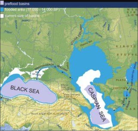
The map of Eratosthenes, drawn in the II century BC, clearly and apparently quite accurately shows the contours of the Caspian Sea (82). Its northern shore is situated to the south of the parallel 45° 30'. This latitude runs through the Kerch Peninsula. The contours of the Caspian Sea correspond to the coastal terrace (which is now under water) at an absolute mark of minus 36 m (meaning the mark of the terrace rear seam, above which a higher terrace ledge rises). Indeed, at that time the Uzboy flowed into the Caspian Sea, as its continuation - the Aktam riverbed - is now visible and can be traced along the sea bed at the absolute mark of minus 32 m. If this bed had been more ancient, it would not have been so well preserved, but would have been covered by aeolian and marine sediments. At a later time, the Caspian Sea did not sink so low and there were no conditions for erosion and meandering. [84-85]
Thus, we can state that with the relative high-water level of the Amu Darya, the level of the Caspian Sea in the IV-II centuries BC was not higher than minus 56 m. It means that according to the climatic scheme accepted by us at the given epoch there was an intensive moistening of the arid zone. History confirms our considerations. In the II century BC the Huns were engaged in agriculture in Dzungaria [26]. At the same time, the Chinese military relays tell about the huge herds, which the Huns and within the Mongolian Altai, and Usuns - in the Semirechye. The Kangyu kingdom, located in the eastern part of Kazakhstan from Tarbagatai to the middle course of the Syr Darya, also appeared at that time as a rich cattle-raising state capable of fielding 200,000 horsemen. The Chu River is shown on the map of that time as flowing out of Issyk-Kul and flowing into a wide lake; nowadays, Issyk-Kul has no connection with the Chu River; the latter is lost in the sands and solonchaks. Everything indicates that these areas were wet and relatively densely populated at that time. But the days of this rich culture were numbered. In the 2nd century BC, the path of cyclones shifts to the north. At that time the Alpine passes become difficult to pass, because of the growth of the Alpine glaciers [85, p. 278]. The tribes of the Cimvians and Teutons, who had previously lived in the lower Rhine, were forced to leave their country because of the floods and found a heroic death under the swords of the legionaries of Marius. By the beginning of the 1st century A.D. the Hun's farming had perished, and cattle breeding had declined and the power of the Huns was broken.
We will not touch the twists and turns of the tragic struggle of a people surrounded by enemies. It is better to pay attention to the way the descendants of the steppe bogatyrs were dispersed. Hunnish people split into four branches. One of them settled on the banks of Huang He and in the foothills of Alashan, where water was in abundance. Another stayed on the banks of the Selenga River and in Transbaikalia, on the border of the taiga zone. The third took refuge on the slopes of Tarbagatai and Dzungarian Alatau, near streams fed by mountain springs, and the fourth retreated to the banks of the Urals and Volga, where, having mixed with the Ugri, they turned into the western "Huns". [26, с. 278]. These latter moved across the steppes of modern Kazakhstan also subjected to desiccation, not in search of grass and water, but fleeing from a cruel enemy, the Syanbi (ancient Mongols). All their movement from Tarbagatai to the Volga took a little over three years, and therefore they left no archaeological remains on their way [27]. In fact it [85-86] was a retreating army, losing transports, wounded and weakened. The "weakened" hid for a time in the Altai mountains and later repeatedly surprised Asia with their valor. The same "indomitable", who, reaching the Volga, broke away from the enemy, gave rise to a new great nation, which in the V century conquered half of Europe - the Huns.
And what was at that time in the steppes of modern Mongolia? What tribes and peoples populated the Huns' abandoned slopes of Xentai and Mongol Altai? There is so little information in the sources that it is safe to say that the country was deserted. But it is not enough to state the fact, it must be explained, and for this purpose the historian is aided by physical geography. Paleontological research in Central Asia have established that the process of desiccation of steppes was interrupted by a period of humidification in relatively recent times [61, p. 189]. Historical science not only confirms this conclusion, but also allows specifying the date of the specified humidification.
P39
Travelers noted that the Mongolian steppe is extremely densely populated. This should be understood in the sense that the availability of fresh water limits the development of cattle breeding, i.e., there are as many cattle as can be watered from the available springs. Wherever there is a puddle of water, there is a yurt and sheep graze. If the source runs dry, the cattle breeder must either die or leave his native country, because in those times the transition to artificial irrigation of the steppes was technically unfeasible. Consequently, the epoch of drying up should correspond to the relocation of nomads from the middle of the steppe to its outskirts.
This phenomenon was observed in the 10th - 6th cc. AD The Huns did not return to their homeland; the Toba from the Kerulen coast moved to the Huang He shores; the oases of the "Western edge" withered away; the Xianbi, having captured the steppe to Tarbagatai, did not settle it, and spread over the southern outskirts of Gobi to Tian Shan. It is possible to find explanations for each of these facts individually, but not for their totality, chronological coincidence and uniqueness of the situation. Even if all of them are coincidences, their sum is already a regularity.
Л. S. Berg, noting that Balkhash has salinity much less than it should have as a drainless Central Asian Lake, suggested that "Balkhash once dried up and later filled up with water again. Since then, it has not yet had time to re-saline". [11, с 68-69]. Our data allow us to date drying up of the most part of Balkhash in the III century A.D. The [86-87] Chinese map of the Three Kingdoms era (220-280) shows a small lake corresponding to its deepest place on the site of Khash. The level of Issyk-Kul was also lowered[10,p.403].
During that period the steppe population significantly decreased, Usuns went to the mountain Tien Shan; Yuebans, descendants of Huns, who replaced them, inhabited the slopes of Tarbagatai, and the once rich Kanpoy descended to nothing. There were no external political reasons that could cause weakening of these peoples, and this suggests that the main role here was played by the physico-geographical process of climate aridization. At the same time, according to the information reported by Ammianus Marcellinus, the Aral Sea turned into an "Axian swamp", i.e. it became quite shallow [85, p. 269]. But already from the middle of the 4 c. the Tele (Uigur ancestors) migrated to the north and the Jurajans found a place to live, a bit later the Ashin Turks retreated there, and they are not at all crowded. There is a struggle for power, not for land, i.e. the very nature of the struggle, determined by the end of the 5th century, points to the growth of population, economy, wealth, etc. The process of initial resettlement of fugitives (Jujani) and separated tribes (Tele) became possible only when free, unoccupied pastures appeared. Otherwise, the aborigines would have offered such resistance to the newcomers, which could not be unnoticed in China and, therefore, should have been noted in their chronicles. But there is a report of relocation and not a word about military clashes, it means that they did not happen, i.e. the Juan-Juan and the Teli occupied the empty lands. And with the marked tendency of nomads to full use of pastures, it must be assumed that new meadows appeared, i.e. moisture occurred.
According to our concept, the drying of the arid zone in the 3rd century A.D. should correspond to an equally sharp moistening of the humid zone. Unfortunately, the state of science in the 3rd century A.D. as well as that of the whole society at that time was far from being brilliant, and hence no direct geographic information about the northern countries has been preserved. However, one fact confirms our viewpoint. In the III century A.D. Goths left the Southern Scandinavia to the southern shore of the Baltic Sea, to the mouth of the Vistula River, and then moved into the area of the middle course of the Dnieper, Pripyat, and spread into the Eastern European forest-steppe, simultaneously conquering the steppe territories up to the Black Sea. Proceeding from the fact that the Gothic subsistence economy [87-88] was closely connected with the conditions of the humid northern landscape, we can assume that in the III century the landscape of the places populated by Goths was also rather humid and not so much different from the Scandinavian one.
Indeed, at this time from Eastern Europe, through the Greek ports Olbia, Chersonesos and others, a huge amount of bread (grain) was exported and consumed by the Eastern Roman Empire. Consequently, the path of cyclones passed through the central part of Eastern Europe, which should have caused moistening of the Volga basin and an increase in the Caspian Sea level. If so, it means that the forest zone was drying up before that and the Volga was shallow. Therefore, most of the present-day delta was a hilly steppe inhabited by nomads like those around it. The main channel of the Volga was the Akhtuba and its continuation Buzan. Probably, this river flowed into the Ural depression, which was connected to the Caspian Sea by a narrow channel.
In the II century, the steppes began to dry up, which reached a maximum in the III century, and, accordingly, the moisture in the forest zone increased. During this period, the Caspian Sea rose to a mark of minus 32-33 m. The Volga River carried so much water that the channel at the time could not hold, and formed a delta of the modern type.
p40
The dry steppes turned into meadows overgrown with willows, reeds, and chacane. In the south, the delta stretched almost to the Buzachi peninsula (north of Mangyshlak), from which it was separated by a narrow channel from the Ural trough. The Sarmatians from the banks of the Volga in the 3rd century AD were driven out by the Huns, who also did not stay in the Volga delta. Beginning in the 5th century, the Bulgars, the winners and successors of the Huns, appeared here, but they took over the steppes, leaving the delta unattended. The moistening of the steppes, which began in the 4th century, also affected the balance of political forces, as well as the past era of desiccation. The Great Turkic Kaganate was created on the place of the Hunnish clan empire. Türkuts (we will call this Türkic people that way, to avoid confusion in the names) created a power much more extensive and stronger than the Hunnish one. From 550 to 580 they subjugated the steppes from the Great Wall of China to the Don River and attached the Sogdian cities on the banks of Amu Darya to their power. They came into contact not only with China, but also with Iran and Byzantium. As a matter of fact, from the 6th century the era of world politics began.
Such a huge country with a multi-tribal population needed an exceptionally flexible and strong state system [88-90]. The Türkiyut system, called "el", involved a combination of the military-democratic form of organization, the horde, with tribal unions [29]. For some time the unity of the empire was preserved, but from 603 it split up into Eastern and Western Khaganates, of which we are interested in the latter.
In the Western Khaganate the Turks proper were in a minority. Besides the khan's kin, a small number of druzhinniks and their families belonged to this tribe. This bunch had to dominate the mighty brave numerous tribes and rich cultural Sogdian cities. Among the subjects of the Turkic khan were the free-loving Telesian tribes of Dzungaria, the Kangars of the Aral steppes, who later became widely known as the Pechenegs, the Bulgarian tribes of the steppes of the North Caucasus, the Barsils who lived between Terek and the Volga, and the Khazars. Strangely enough, all these peoples supported the dynasty, so it existed until 659. Obviously, the presence of a weak government suited them better than the constant tribal wars that would otherwise be inevitable. But the double blow from the outside was fatal: the Arabs invaded Sogdiana, the Chinese conquered the Tarim basin and Dzungaria, the last khan was taken captive, and members of his family moved to Khazaria, and from that time the Khazar Khaganate arose.
This brief account shows that in the 6th-8th centuries, the steppes provided life for the nomads. But not only these indirect considerations allow us to consider the Turkic-Turkic time as an era of increased moisture. The contours of Lake Balkhash on the Chinese map of the 9th century remind the depression of the basin, which also contains Lake Alakol [14, vol.III, cf.: 56, p.129]. The same map shows that the Sarysu and Chu rivers, now lost in the sands and salt marshes, formed extensive lakes, corresponding to the modern dry depressions. And if so, not only the Volga delta, but also the Don valley turned into paradise gardens, and the rise of the culture of the peoples inhabiting them had a solid base in optimal natural conditions.
It was at this time and in these conditions formed two mighty nations: the Bulgars and the Khazars. They had many cultural similarities, but the Bulgars remained steppe people, cattlemen, hunters of wolves and foxes, while the Khazars were inhabitants of river valleys, farmers, fishermen, who resembled the Greben Cossacks and the Astrakhan Tatars in their everyday life. [90-91]
Next, there was a gap in our hypothesis. What were the changes between the 7th and the 13th centuries, we did not know, and left that epoch in question. But from the end of the XIII century, the rise in the level of the Caspian Sea was noted by many contemporaries. The Italian geographer Marino Sanuto wrote in 1,320: "The sea is rising by one palm every year, and many good towns have already been destroyed" (12, p.220). Indeed, the Persian port of Abaskun was flooded by the sea in 1,304. [39, с. 8]. Persian authors of the 14th century explained the unprecedented rise of the Caspian Sea by the fact that the Amu Darya, having changed its course, began to flow into the Caspian "by necessity the water flooded part of the mainland to equalize the inflow and outflow" [9]. [9, с. 7]. As we already know, the change in the level occurred for completely different reasons, and therefore we can imagine the climatic conditions at the beginning of the 14th century. The lower Volga burned from heat, while the upper Volga was raining; Tatar cattle died from fodderlessness, Russian bread rotted at the root waterlogged; steppes turned into deserts, forests - into swamps. Even the last refuge of the people - the delta and floodplain of the Volga were flooded with water, and only the Baer knolls rose above the surface of the shallow sea, like an archipelago of small barren islands. The water reached a mark of minus 19 m. Just as the shells of cardium edule show the level of water rise from the sea, so the ceramics of the VI-X centuries, which we found in the Caspian steppes, marks the coastline from the land side. The only difference is that the pottery indicates not only the height, but also the date of sea level rise, which cannot be obtained in any other way.
Since the middle of the 16th century, the level of the Caspian Sea could be established by the usual way of measuring and referencing. This was done by the academician L.S. Berg [12, pp. 266-267] and refined by B.A. Apollov [4].
p41
However, it was not fundamentally changed by B.A. Apollov [4]. But we continued our analysis to check the correctness of our concept of heterochronous moistening, and obtained the following results. In 1,556, the Russians built Astrakhan on the right bank of the Volga River 13 kilometers below the old Tatar city. Judging by the height of the ramparts surrounding the city, L.S. Berg established that the sea level was at minus 26.5 m [12, pp.225-227], i.e., it had dropped by 7.5 m in 200 years. It means that the upper Volga was in the stage of desiccation, but the steppes were also desiccating very intensively at that time. It was during this era, the population left the cities in the lower reaches of the rivers flowing down from the Kunlun and Nanshan. Nomads by whole tribes left their native steppes, but they left not for conquests, not for predatory [91-92] campaigns, but in search of watering places and pastures. Chinese geographers of the 17th century wrote: "All Mongolia has come to a movement, and Mongolian clans and tribes scattered in search for water and good pastures, so that their armies are no longer united" [quoted from: 22, p. 437]. Indeed, at that time all steppe peoples weakened, except the Oirat, who used the mountain valleys of the Altai, Tien Shan and Tarbagatai, where there were both glacial and subsurface waters.
But if desiccation also took over the forests and steppes, it means that the Arctic was moistening. Indeed, Chancellor in 1,553 easily reached the mouth of the Northern Dvina. During the XV-XVII centuries, the entire North was developed by Russian settlers, who settled along the banks of rivers and, therefore, did not suffer from the swamping of the tundra. Pomors went to Spitsbergen and Novaya Zemlya, Cossacks founded Mangazea. The center of gravity of economic activity imperceptibly, but steadily shifted to the north.
The reverse process began in the second quarter of the 18th century. The Caspian Sea began to rise again and by 1804 reached the mark of minus 22.3 m. This meant that the maximum rainfall began to fall in the Upper Volga basin, although not as intensively as in the XIII-XIV centuries. Now the steppes of the Northern Ukraine, the Upper Don, the Middle Volga became the most convenient lands. In a short time they were covered with villages and stanitsas. Since the early 19th century the level of the Caspian Sea was slowly falling, and the ice of the Arctic was gradually melting. The Northern Sea Route was developed when the current Komsomoltz Bay dried up. The question suggested itself: how will climate change proceed? But we could not give a forecast. After all, all of the above was a hypothesis, the truth does not meet the contradictions, but not tested to the end. With this we ended our message. (end of report).
***
Reading a report in a scientific meeting, one can never be sure of success. The worst thing is if the speaker fails to state his idea clearly enough to be fully understood. It is bad when listeners get bored and feel that the report is a repetition of what has long been known. There is a risk of appearing paradoxical, striving for originality and only for the sake of it, neglecting the usual norms of scientific research. Finally, there are times when the argumentation seems insufficient and the conclusion hangs in the air. [92-93]
Therefore, in presenting our concept, built on a variety of material, in the presence of scientists of different specialties, we could expect any disagreements or doubts. Many questions arose about the report, but, contrary to our fears, there were no objections to the principle and methodology at all. The individual amendments concerned individual details and did not bend the guiding idea. The main doubt was caused by our hypothesis about the too late date of the Caspian Sea transgression. Usually, it was dated by the post-glacial period or, translating into the language of archaeology, by the Upper Paleolithic epoch. This thesis did indeed require additional evidence, but the unresolved problems did not affect the success of the report. We were praised already for raising them.
The report was recommended for publication, and the continuation of the work in this field was approved. The Khazar-Caspian problem received the rights of citizenship.
Plans, hypotheses, and dreams
Before starting the field work, you are supposed to justify them. I put forward three questions. The first is an excavation of the Khazar burial ground on the hillock of Stepan Razin. There was no need to prove and convince; everyone understood that, if successful, a new archaeological culture, the importance of which for history, would be discovered.
The second question - the change in the level of the Caspian Sea during the historical period, seemed to go beyond the limits of archaeology, but the hypothesis about the impact of changing natural conditions on the ancient peoples, in particular the Khazars, seemed fruitful, and I received permission to deal with it in passing, especially since this topic did not require additional costs. If the head of the expedition wants to write something in his diary in his free time, then good for him and good for science.
But I wanted more! Geologists have established that on the shores of the Caspian Sea there are a number of so-called "coastal terraces" - platforms knocked out by the surf. These terraces show ancient standing of the sea level, and some of them are nowadays covered with water.
p42
Thus, the lowest terrace is at an absolute mark of minus 36 m, the second - minus 32-33 m, modern - minus 28 m. The higher ones I was not yet interested in. I put the third question, decided to establish the standing of the Caspian Sea at these marks and invented the following method. [93-94]
The city of Derbent is protected from the north by a huge wall. The western end of this wall goes into the inaccessible Caucasus Mountains, and the eastern end descends into the sea. Nowadays, the eastern end is destroyed, but in calm weather you can see the plates of the fortress wall through the clear water.
The most valuable thing was that the date of construction was known precisely. The wall was built by order of the Persian Shah Khosroi Anushirvan in 562-571. North Caucasian nomads easily passed into Transcaucasia through the valley between the slopes of the Caucasus Range and the shores of the Caspian Sea and plundered the sedentary population of the northwestern edge of the Persian kingdom. To repel them, it was necessary to maintain a large army, which was expensive and did not always yield good results, because the swift steppe tribesmen often managed to escape with the loot from the heavily-armed Persian cavalry. For these reasons, the Persian king decided to block off the valley with a wall, impregnable to steppe horsemen, who did not know how to take fortresses. Indeed, after the 40 km long wall was built and a fortress for the garrison was built, the attacks of small groups of nomads stopped, and major wars at that time occurred infrequently1.
The underwater part of the Derbent wall, described only by three Arabian geographers of the 10th century: Abul Faraj Kudama, who visited Derbent in 948; Istahri, whose description is dated 930; and Masudi, the author of the book "Golden Meadows", the most capital geographical composition of the 10th century.
As usually happens, the information of the sources contradict each other. Kudama writes that Anushirvan built a breakwater from stone blocks and lead 2, and on it continued a wall, which went into the sea for three Arabian miles, i.e. about 5 km [45].
Masudi defines the length of the seaward section of the wall as only one mile, and describes the construction technique differently. According to him, the stones were loaded into the drums and lowered to the bottom, after which the divers cut through the drums with knives and took them out to put them back into use again. At that it is not clear at all, how the cut wineskin could be used, and [94-95] why it was necessary to load it with stones, when it was easier to put it back [78,79].
Istahri writes that "between the sea and the roadstead the walls are built parallel to the sea; the passage between them is narrow, and the entrance to the port is made winding. At the entrance to the port a chain is stretched, so that a ship cannot enter or leave the port without permission [77]. What are these walls? The plan of Derbent shows two walls bounding the ancient city from the north and south. But they run perpendicular to the sea and are separated from each other by almost half a kilometer.
In short, all the descriptions are so unsatisfactory that it is impossible to base any considerations on them. It was necessary to examine the wall myself and to determine what depths were around it at the time of its construction. I hoped that I would be able to do that, and asked M. I. Artamonov for additional money for underwater archeology. And to work at the excavation he seconded to the expedition a candidate of historical sciences 3. A. Lvova.
So the expedition was organized, from which one could expect either a huge success, or an equally huge failure. But what happened in Derbent and the Volga delta will be told further, not in chronological order, but in separate chapters.
.