


1. Historical Geography as a science, discovering Khazaria
Lev Gumilev was a consummate scientist. He often wrote about the practice of his profession, and the rigor needed to discover ancient history. Here we will have 5 chapters on the story of Khazaria.

Much of this is about methodology, but here starting out are some great background materials for what "we are searching for". Some people have commented that you can never trust history's distortions. Written for particular interests and with particular backing, the historian must satisfy the needs of their mentor. Often true, but please take a look at this thread. I hope that you will find it interesting.
[Note: I actually have much material prepared for upload, and that is destined to be on this site. More on the detailed history of the Mongols, on Russia, on the Theory of Ethnogenisis, more on the Chinese. It will probably break down to 50 chapters or more. I also would like to add some classical period literature, to better feel people's lifestyle. Can you get a true picture of life from fiction writing of the time? I am trying to move cautiously, because each upload is an email sent to you. So I may be stretching this out until March, and in the mean-time, what else will come up?]
THE DISCOVERY OF KHAZARIA
(HISTORICAL AND GEOGRAPHICAL SKETCH)
This is the author's thoughts and feelings that arose during his five-year journey through Khazaria, both in space and time, or it is the biography of a scientific idea.
Written in 1965 AD.
From the fall of the Khazar Kaganate, and dedicated to my dear teacher and friend Mikhail Illarionovich Artamonov.
INTRODUCTION
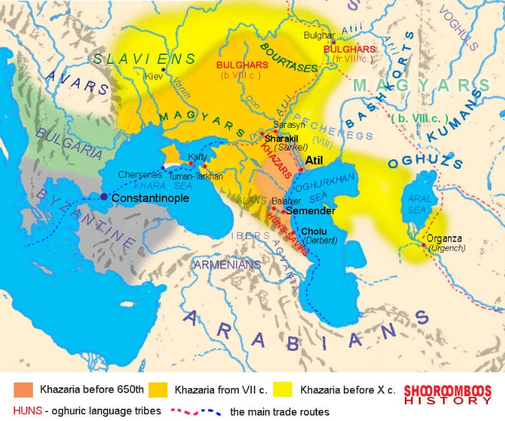
The reader, historically educated, knows that the Khazars were a powerful people, who lived in the lower reaches of the Volga, confessed the Jewish faith and in 965 AD and were defeated by Prince Svyatoslav Igorevich of Kiev. The reader – the historian or the archaeologist - raise many questions: what was the origin of the Khazars, what language they speak, why did their descendants not survive, how could they practice Judaism, when it was a religion, the conversion to which was prohibited by its own canons? And most importantly, how did the Khazar people themselves, the country they inhabited, and the vast Khazar kingdom, which covered almost all of Southeastern Europe and populated by many peoples, relate to each other?
Among the subjects of the Khazar king were Kama Bulgarians, Burtases, Suvars, Mordva-Erzyas, Cheremisses, Vyatichi, Northerners and Slavs-Polanians. In the east this kingdom bordered on Khorezm, i.e. owned Mangyshlak and Ustyurt, and thus all the steppes of the Southern Urals. [45-46] (I think these are page numbers before translation from the Russian, which I included if I reproduce the index.)
(I will reproduce this map and others on every chapter for your reference. And/or, open it on another browser tab.)
In the south the border city was Derbent, whose famous Wall(1) separated Transcaucasia from the Khazar possessions. In the west, the entire North Caucasus, the Steppe Crimea and the Black Sea steppes to the Dniester and Carpathians were subordinated to the Khazar king, although they were not inhabited by the Khazars, but by the Alans, Kasogs (Circassians), Pechenegs and Hungarians, who had not yet moved into their present territory.
But the borders of the state almost never coincide with the borders of the settlement of the people who created the state. They can be narrower or wider, depending on military successes or failures. The territory outlined by us was the border of the kingdom, but where the Khazar people lived - the written sources do not indicate.
Moreover, the fortress on the Don excavated by Professor M.I. Artamonov, which he identified as Sarkel, one of the Khazar fortresses mentioned in the Russian annals and in the Byzantine chronicles, has no archeological remains which can be directly attributed to the Khazars [6, p.27ff]. In pre-Khazarian times there was an Alanian settlement, after Khazars there was a Russian town Belaya Vezha, and during the heyday of Khazar power a fortress, the garrison of which consisted of three hundred hired warriors, who were replaced annually [51, p. 20]. The graves around the fortress belong to the nomadic Huzes or Pechenegs, who apparently served in the Khazarian army [65, p. 153ff]. And in other places, which have been visited by archaeologists, monuments of Khazar time belong to the subjects of the Khazar tsar, but not to the Khazars themselves. Therefore, everything that is known to historians refers to the Khazar state as a whole, but the territory where the Khazar people lived does not coincide with the boundaries of the entire empire of Khazar Kagan1.
The name "Khazars" was already known to the first Russian chronicler, the author of "The Tale of Bygone Years", and since then it has been mentioned in Russian historical literature repeatedly. However, who are the Khazars and what is Khazaria, no one really knew, because unlike other nations, who had ancestors and descendants, neither of them, nor any others were found from the Khazars. Moreover, the nationality, which for almost a whole millennium lived in such a well-studied area between the Volga, Don and Terek, where, according to [46-47] all chronicles, was placed the Khazar Khaganate, for some reason it did not leave behind any archaeological monuments. Khazars, like all other people, ate and drank, and, of course, broke the dishes, but where are the shards, the material, which is always the first find of archaeologists? Khazars had two major cities: Itil on the Volga and Semender on the Terek - and where are their remains? The Khazars were dying - where did their graves go? Khazars multiplied - with whom did their descendants merge? And finally - where were the Khazar settlements, the very "villages and fields," which, according to Alexander Pushkin, "were doomed to swords and fires. All this remained unknown for a long time!
1 Khagan, - from the 3rd century the title of the king among the Turkic-Mongolian nomadic peoples.
p22 Russian page number
Usually, the territory once inhabited by any people to be studied is found without difficulty. Sometimes there are disputes about determining the boundaries of the area of settlement and the time of settlement of certain areas, but these are details of the same problem. But the restoration of the history of the people is met with various and not always surmountable difficulties. In resolving the Khazar question, it was just the opposite.
Neighboring nations left a vast amount of information about the Khazars, sometimes coinciding, and sometimes mutually exclusive. Byzantine Greeks entered into alliances with the Khazars and sent them Orthodox missionaries. The Persians and Arabs fought with the Khazars, but Muslim merchants were so important that they had in the Khazar capital their own special quarters and a mosque, Russians from Kiev and Chernigov paid tribute to the Khazars with double-edged swords, and gathering their forces, in 965 AD, went through the Khazars, cutting with such swords, Khazar heads.
The Armenians and the Georgians, who suffered misery from Khazar invasions, wrote about the Khazars. But perhaps the document that gives the most exhaustive information about the Khazar people was a letter of the Khazar king Joseph in Spain to the dignitary of caliph Abdrahman III, Hasdai ibn Shafrut, written in the middle of the 10th century.
Based on these numerous documents, my teacher and friend, Professor Mikhail Illarionovich Artamonov wrote a major work "History of the Khazars", but the geography of this country still remained in a primitive state. Thus, a strange disproportion was aggravated: we can easily read what victories the Khazars won and what defeats they suffered, but, as has already been said, about where they lived, what was their life and culture, we have no idea. [47-48]
One of the Russian educators of XVIII century, N.I. Boltin, wrote: "At every instance ... There is an indisputable fact that history and geography mutually aid each other, that is, one clarifies ambiguities and shortcomings of the other and supplements them". [quoted from: 89, p. 274-275]. This is an axiom for political history! In order to understand the course of this or that battle, in some cases such seemingly minor details should be taken into account, as for example, relief and season (as there are cases when impassable mud delayed the attacking formation); absence of water sources (for horses), which forced changing positions; presence of hills or ravines, which prevent the formation of troops. It is even more important to imagine the whole area through which the troops are advancing or retreating. Knowing a map of the terrain is too little. If it is a desert or a flooded river valley, you can't tell its true character from the map, but on terrain viewed from a particular angle of interest, all the details catch the eye.
Then, the landscape always determines the type and methods of farming. The long dispute about whether the Khazars were nomads or farmers would be solved if it became known where their settlements were located: in the dry steppes surrounding the lower course of the Volga, or in the river valleys? But in resolving this question, one should also take into account the fact that for two millennia the landscape had not remained unchanged. There are as many reasons for this phenomenon as there are attempts to determine them. One thing is clear - the nature of moisture changed, and, consequently, the coastline of the Northern Caspian Sea, where the land gradually turns into a shallow sea, moved radically.
Equally, steppes in periods of droughts turned into sandy deserts with high barchans and deep blowing hollows, while in wet periods they were overgrown with steppe grasses and tamarisk thickets, turning into a paradise for shepherds and their sheep. The balance of power between steppe and river valley dwellers was changing and was sensitively reflected in the history of the Lower Volga region.
And also - it is known from the descriptions of travelers that Khazaria actively traded with Persia, Khorezm and the Byzantine Empire in the south, with Russia, Great Bulgaria and Great Perm (Biarmiya of the Scandinavian sagas) in the north. But how did the Persian merchants, who exchanged silver for precious furs, pass from south to north? Did they go through the barren deserts of the Aral Sea region, or did they sail through the stormy Caspian waters in order [48-49] to go up the Volga? In both cases there are pros and cons, and it is not clear whether the routes did not change over the long years of the Khazar Kaganate, in the years of its greatness and in the years of deep decay? And where were the transit points, the blooming towns of Itil and Semender, where merchants and travelers rested in green gardens and stocked up on food for the second half of the arduous journey?
Finally, why the courageous Russians on their light boats did not touch Khazaria and furrowed the green waves of the Caspian Sea until the beginning of the 10th century? After all, they appeared in the Black, Northern and Mediterranean seas a hundred years earlier. And how come that in the XIII century, when the Khazars were still seen by the Italian monk Plano Carpini, the country of Khazaria became an unknown land? И... but that's enough for now! We have outlined the range of issues to which history cannot answer independently, ceding its field to historical geography.
p23
Although the sources on the Khazar history were known for a long time and were studied very thoroughly, the opinions of scholars about their culture, language, territory, way of life were not unanimous. An extreme point of view was formulated by the famous Orientalist of the mid-nineteenth century. V. Grigoriev and our contemporary, Academician B. A. Rybakov. The first concept, expressed in 1834, based on the information from Arabic sources VIII-X centuries, which just came into historical use, idealizes the Khazar Khaganate: "An unusual phenomenon in the Middle Ages was the Khazar people. Surrounded by wild and nomadic tribes, they had all the advantages of educated countries: an organized government, a vast, prosperous trade, and a permanent army.
When the greatest powerlessness, fanaticism and deep ignorance disputed each other’s dominion over Western Europe, the power of the Khazars was famous for justice and faith-tolerance, and those persecuted for their faith flocked to it from everywhere. Like a bright meteor, it shone brightly on the gloomy horizon of Europe and went out without leaving any trace of its existence. [69, с. 66]. The absence of "traces of existence" really casts doubt on the conclusion of V.V. Grigoriev.
The Khazars were mentioned for the last time in the XIII century among the peoples who submitted to the Khan Batyi [67, p. 46, 57, 72]. This era is already well known. Not only Arab merchants and Russian chroniclers, but also Italian missionary monks, observant and educated, described from different points of view the nature and population of the Caspian steppes, including the Khazars. But they [49-50] always somehow bypassed the question of the Khazar territory, where the monuments of material culture were to be preserved. Not only that, the cultural development is always associated with writing, all neighbors of the Khazars - Greeks, Armenians, Persians, Arabs, Russians - had a developed literature, and from the Khazars remained only three epistles written in Hebrew [50]. And whether so well was arranged at Khazars board if one campaign of Russian prince was enough for full defeat of great power? And where could the people disappear, which used the benefits of trade and contained a constant army? No, there is something wrong.
Diametrically opposed to the point of view of B. A. Rybakov. He calls Khazaria a "small semi-nomadic state" of "parasitic nature," which was living off of transit trade, "predatory use of the benefits of their position”. He places the center of Khazaria in the Kalmyk steppe and states, quite correctly, that there are no "archaeological traces of Khazar cities" [72, 131]. [72, с. 131]. They really do not exist there.
The most interesting is that B.A. Rybakov's skepticism is based on the same sources as V. V. Grigoriev. This is not evidence of the inability of scientists to use the information of the ancient authors, but we must admit that since such different conclusions are possible, it means that the available sources are not enough.
It is impossible to agree with B.A. Rybakov, because even before the trade followed the Volga route, the Khazars already had a strong and not at all mercenary army, which in 627-628 years saved Emperor Heraclius from defeat. Only the ruling elite could "parasitically" prosper, and besides them there were people who lived at the expense of their own economy and continued to exist after 965, i.e. after the destruction of the Kaganate. Finally, the absence of archaeological monuments in the steppes says only that they should be sought elsewhere.
In contrast to V. V. Grigoriev and B. A. Rybakov, M. I. Artamonov considers the history of the Khazars in a dynamic formation. He carefully highlights the "urban" period when the ruling top of Khazaria, alien to the people by blood and religion, became rich by trade, relying on mercenary guards - Turkmens. Equally, he states that nomadic life, described in "Khazar-Jewish correspondence", was connected with the customs of khan's kin, belonging to Ashina Turkic dynasty, which had not abandoned its traditions. This author leaves open [50-51] all unclear questions, already listed by us, about the Khazar people, because the material at his disposal did not give him a basis for categorical judgments. Therefore M.I. Artamonov notes: "So far, the location of the most important cities of Khazaria, Itil and Semender, and their material remains are unknown”. Not only tombs of Khazar Khagans have not been found, but, in general, Khazar burials are unknown" [7, 412]. [7, с. 412].
In other words, the territory where the Khazar people actually lived has not been discovered so far, although the boundaries of the Khazar Kaganate were quite accurately known.
These three concepts essentially exhaust the options for solving the Khazar problem. Despite the extensive literature on the issue, all other opinions either can be reduced to one of the three outlined concepts, or lie in between. Most of the works are devoted to private issues of Khazar-Byzantine, Khazar-Russian, Khazar-Arab relations or clarification of certain chronological details and do not have any conceptual generalizations.
That's why we do not discuss these works here, referring the reader to M.I.Artamonov's book [7, p. 7- 37].
p24
And how can a non-specialist reader, if he suddenly wants to find out not about a large and long-term scientific polemic, but about Khazars themselves? If even in the mass of books and articles among the many points of view there is one correct one, the unprepared reader will not be able to distinguish it from the other false ones. The only way to help him is to lead him, as Virgil led Dante, by the hand through the thicket of opinions and doubts, failures, forcing the scholar to abandon the beaten path of research and success, encouraging and pushing forward, thus enabling the reader to form his own opinion.
This is how this book is structured. It is a biography of scientific discovery. Therefore, equal space is given to descriptions of the subject and the method of research, to archaeological finds and meetings with colleagues, to painstaking study of history and thoughts that appeared, at first glance, by chance, "but proved fruitful, to detailed accounts of routes, and impressions of the beauties of nature".
All this mixes and merges in a single process of historical synthesis, and one can never say what has proved most important for comprehending the truth: whether studying the sources in originals or translations, whether reading the historical [51-52] works of modern scholars, whether describing crocks and beads from ancient sites both under the hot southern sun and in the silence of the study, or perhaps it is a conversation with a scholarly friend, an expert in another field, sharing his knowledge, or one's own association, born from a long reflection alone with oneself.
May the reader not blame me that this book will tell not only about the Khazars and their country, but also about the routes and books I have read, about my companions and interlocutors, about disputes and their decisions, and even about myself.
CHAPTER ONE, SEARCHING FOR ITIL.
Conversation One (with M. I. Artamonov)
One spring day in 1959 I entered the reading room of the Hermitage library and saw Professor M. I. Artamonov looking at a map of the Kalmyk steppes. "How many kilometers in farsakh?" - he asked me gloomily. I recalled the generally accepted value of 5.5 kilometers, but the professor muttered: "It doesn't work," and invited me to the map. The point was this, Khazar King Joseph, in a letter to Hasdai ibn Shafrut, described the annual summer migrations of his court. In the spring, he left his capital Itil, located on the banks of the Volga, and moved south to the river V-d-shan. Then he migrated north, apparently avoiding the summer heat in the arid Caspian Sea regions, but moved not home, but to the river Buzan, identified with the Don, and from there returned to his Itil, located 20 farsakhs from Buzan [50, p. Here the tsar Joseph informs distances from his capital to the borders of his kingdom: east to the Hyrkan, i.e. Caspian Sea - 20 farsakhs, south to the river Ug-ru - 30 farsakhs and north to the already mentioned river Buzan and "to the slope of our river to the Hyrkan sea", i.e. to the convergence of bends of Don and Volga in modern place of Volga-Don channel - 20 farsakhs. Thus, all distances are calculated from the capital [52-53] of Itil. Consequently, in order to find the place of the capital, M.I.Artamonov built a triangle on the map, with its tops resting on the Don (Buzan), Volga (Itil) and Terek (Ug-ra) rivers, with the length of the sides proportional to the given distances.
However, the established length of farsakh - 5.5 km contradicted its construction. If to take this length as a basis and to base the triangle tops on Don, and even if not on Terek, but on Kuma and Manych, the capital of Khazar Khaganate should be in the steppe of Northern Kalmykia, near the Sarpin lakes. That alone contradicted sources, which placed Itil on the bank of Volga, and in addition disappeared a large river V-d-shan, located 10 farsakhs to the north from the frontier river Ug-ru [72, p. 141-145, cf.: 7, p. 385-390]. The task seemed unsolvable, and that is what made my teacher think. [53-54]
And then a distant association suddenly flashed through my mind. As a young man, back in 1932, I happened to work in Tajikistan as a malaria scout. My job consisted of finding swamps where mosquitoes were hatching, plotting them and then poisoning the water with "Parisian greens". The number of mosquitoes decreased somewhat, but the ones that survived were enough to infect not only me but the entire population of the area with malaria. I made the most of this work, however, because I mastered sightseeing and the spoken Tajik language. As I repeatedly had to refer to locals when determining distances, I willy-nilly learned the Central Asian measure of length - chakrym. To determine the length of a chakrum in meters was Impossible.
1 In the short version of the letter the distance from Buzan to the capital of Khazarin - Itil is 30 farsakhs [50, p.81-83].
p25
It was then long, then short, but there was a strict regularity in the variations. If to go uphill or through a bog - chakrim is short, if to go downhill or on a good road - long, and all other values were located between these limits. As a matter of fact, the chakram was not a measure of length, but of the effort and time one had to expend to reach the goal. It must be admitted that this system of reference was very convenient for the natives, though completely unsuitable for mapping. Then it occurred to me that the Tajik "chakrum" was nothing like the Persian "farsakh" (an Arabized form of farsakh), and then it was necessary to consider not the abstract length, but the cross-country traversability. We immediately estimated the distances, built a triangle, and it turned out that, with the length of the Khazar farsakh 10 km, the river Ug-ru - Terek, the river Buzan - Don, V-d-shan - Kuma, and Itil should be on one of the banks of the Volga between the villages Yenotaevka and Selitrenny.
It remained for the last to prove that farsakh is really not a definite measure of length, but an approximate measure that depends on the topography and the state of the roads. There is no indication of this in European literature, but the case was saved by a 19th century Persian novel. "The Journey of Ibrahim-bek," written by Zein al-Abi-Din Marghai. It describes the experiences of a Europeanized Persian patriot who lived in Alexandria and visited his ancestral homeland. He describes Persia with very gloomy colors, but among other things there is a maxim that the Persian arbakeshs are such savages, that they even can't measure distances, and the long and short road is "one [54-55] farsang" [see 57]. [see 57, p. 194]. This consideration helped to resolve the question, and soon M.I.Artamonov offered me to go to the bank of the Volga and to find there the capital of Khazaria, the place of which he calculated with sufficient accuracy. I enthusiastically agreed, and the expedition was scheduled for September 1959.
According to the descriptions of Arab and Persian geographers (for a summary of the information about Itil, see B.D. K. Kovalev, "The Capital of the Khazars", eds: 88, pp. 255-261] and the letter of tsar Joseph [50, pp. 84-86,102], Itil was a big city, situated on a long, narrow island and on both banks of Volga. The island was connected to the right bank by a bridge, and to the left bank it was necessary to cross it by boat. The size of the city varies from author to author and is rather vague. However, all emphasize that the city was vast and crowded, although there were no brick buildings except for the Khan's palace. It is indicated that there were many trees in the city, and the wall surrounding the city was even compared with the wall of Urgench [7, p. 394-397]. On the one hand, the number of signs and authoritative evidence seems to be quite enough, but on the other hand, it is not clear how such a monument could remain unnoticed, when even the remains of villages cannot hide from the keen eye of the archaeologist.
The banks of the Volga are densely populated, and if the city was located there, it probably would have been found long ago. Still, M. I. Artamonov's considerations were so convincing that a trip to the site seemed necessary to verify them.
Journey 1959. First Failure
In early September 1959, from Leningrad left the Astrakhan archaeological expedition, consisting of Lev Nikolaevich Gumilev - head of the expedition, Istvan Erdei and Vasily D. Beletsky - employees of the expedition. In Moscow, Andrey Nikolaevich Zelinsky, a graduate student of the history department of Moscow State University, joined the expedition. We took him on as a worker, and we were very glad to welcome him, as he turned out to be a useful worker and a good companion.
As true "field men," we began our first observations from the windows of the Astrakhan train. Early northern autumn with slush and drizzling rain was behind us as soon as we crossed the Volga. The bright blue of the sky was somehow in particular harmony with the pale yellow of the dried grasses, powdered with fine dust. Strangely enough, neither the faded grasses nor the dust seemed dull or joyless. Everything was saturated with sunshine: the grass, the dust, the melancholy [55-56] camels, and the boughs, powerful willows with pale green, narrow leaves that fluttered in the faint breeze. Steppe grasses are much more caloric and nutritious than the fresh greens of northern marshy meadows, and they were enough to feed herds of domestic and wild animals. Here I began to learn to "read the landscape," an art that determined the fate of the expedition.
We stayed in Astrakhan only until the steamboat, which dropped us off in the morning of September 8 at the pier of the village of Enotayevka, on the right bank of the Volga.
It should be noted that the Volga, flowing up to Volgograd as a single mighty stream, after it turns southeast, splits into two channels: the western one, the Volga proper, and the eastern one, the Akhtuba. Between both channels lies a long strip of land, flooded during spring floods. This green island, covered with meadows and willow clumps, is sharply disharmonious with the dry steppe of the right bank of the Volga, where only sparse bushes stick out on the cracked brown loamy soil stunted vegetation.
p26
And yet all the villages are located on the high bank of the Volga, because spring floods would destroy any structure erected in the floodplain. So we ignored the enchanting greenery of the opposite bank and directed our routes north, south and west, hoping to discover the remains of the ramparts of Itil, or at least the shards of crockery broken by Khazar women.
But we found nothing! Not even the features of the relief, which corresponded to the description of Arab geographers. In three days of work, it became clear that there was no Khazar capital on the right bank of the Volga1.
But this was not yet a failure! For further searches it was necessary to cross to the other side, but crossing in a straight [56-57] direction was impossible. The width of the floodplain in this place is 18 KM, and there are no roads across the floodplain. We had to go down by bus to the village Seroglazka, cross two channels by boat: the Volga and Brick Creek and get to the road on the left bank of the Akhtuba.
Here we found ourselves as if in a completely different country. The sandy desert stretched eastward; high barchans, (crescent-shaped dune), approached the river bank and towered like mountains near the exposed slopes and bluffs of the coastal hills that were washed by the river. Here there was no virgin emptiness of the Kalmyk steppe; on the contrary, the wilderness breathed with antiquity. This feeling, familiar to every experienced archaeologist, is impossible to describe or convey. The presence of finds is felt by all surface of the skin, but it not always those finds for which the archaeologist has gone on a way. We came across an abundance of red, well-burned shards of vessels made on the Potter's Circle, sometimes with azure or green watering. These were traces of the Tatar settlements of the XIII-XV centuries. - outskirts of the luxurious capital of the Golden Horde khans - Batu Khan's Saray2.
This city, one of the capitals of Eastern Europe, was huge. The remains of houses are found 5 km deep into the river and almost 7 km along the bank of the Akhtuba. Most of the buildings were dismantled back in the 16th century, and bricks went to build the Astrakhan Kremlin. Now only foundations, ruins and huge vessels like amphorae, dug into the ground and used as granaries, are preserved. We have thoroughly examined all the bank of the Akhtuba, but have found no traces of Khazar, or at least pre-Tatar, rough, stucco, badly burned ceramics of the Turks in the 7th-10th centuries. However, the confidence that we found on the right bank of the Volga did not appear either. The sands, blown over by the winds, cannot keep the pieces of pottery on the surface. It inevitably sinks to the solid ground and rests under the barchans. Sometimes, the wind blows a deep hole, and one can find there shattered shards, but it is a matter of chance. There may be a cluster of shards nearby, five or ten meters away, which would shed light on our questions, or there may be nothing there either, for nothing can be seen under the mountain of sand.
So not even a negative conclusion could be made, i.e. no conclusion at all, and this is the worst of all. And then, in despair from failure of searches, I sat down on the bank of the river and reflected. It seemed to me [57-58] ridiculous that people without a great need would live on the high bank, where it was so difficult to drag water from the river. After all, it is much more convenient to live near the water, on the other bank of the Akhtuba, where in the wide floodplain in the green meadow grew low surprisingly picturesque willows. Is it possible that the entire floodplain is flooded during spring floods? Aren't there any high places there that are livable? Has the river always risen as high as it does now? And then I made a decision, completely incongruous from the point of view of normal archaeological exploration - to start looking for a town in the floodplain, where no one has built a single house in the last 200 years, because every spring the raging waves of the Volga roll across these magnificent meadows.
The chairman of the village council kindly allowed the expedition to use his fishing boat, and we, overcoming the unexpectedly fast and powerful current, crossed to the left bank of the Akhtuba River and went upstream, carefully exploring every meter of land.
The first thing we came across was a rather high sandy hill, on top of which stood a house - a poultry farm. The house was in good condition, so the floods had not harmed it. The most interesting thing, though, was not that, but that the hill was of aeolian origin. The sand that formed it had been carried by the wind from across the Akhtuba River and for some reason fell out in one place only. This could only be the case if there had once been a wall or other barrier in place of the hill, behind which formed.
1 An inspection confirmed the original conclusion. The modern bank of the Volga was formed recently, by erosion. Thousands of years ago it was a loamy steppe with an undivided relief.
Neither remains of settlements, nor even shards of broken crockery around Yenotaevka were found. Moreover, when the next year I managed to pass by this village again, in the rim of a low hillock were found exposed human bones: the skeleton was cleaned up and turned out to be a Sarmatian warrior, he had an iron sword and a vessel. If there had been a large city above it, the above-ground burial would not have survived to our time.
We can be sure that Itil was not located here. Below, near the village Seroglazka, where the coast is less washed away, a variety of pottery was found in the coastal rim and blowing hollows. This place was inhabited in ancient times, but no walls or remains of buildings were found, and the configuration of the relief does not fit the description of Itil.
2 The first Sarai (palace), built by Batyi, lies near the village of Selitnoye; the second, built by Khan Berke, is higher up the Volga.
p27
The air swirl, where the sand fell, which in all other cases was carried further west by the wind. Having noted this, we moved upstream of the Akhtuba River.
Fortunately, in 1959, the Volgograd Sea was filling up with water and the level of the Akhtuba was lower than usual. Therefore, below the low hole a wide (about 20 meters) strip was exposed and the hole itself was visible, like on a geological section. Above, the yar, only ordinary Tatar shards were found, but on the dried-out strip began to be found molded, rough, badly burnt shards of IX-XI centuries. There was no way to determine how they were there: had they been dragged by water? Were they deposited together with the shore? Suddenly, they were found: a shard of the 9th-XI centuries sticking out from the washed-out bank, exactly dating the layer where it was laid. And 2,3 m of river deposits above it, formed, therefore, during the last thousand years, because a small shard could not have sagged down through dense alluvial clay. And if so, all our searches on the surface are fruitless, because the horizon we are interested in is at a depth of 2,3 m. [58-59] We had only one thing to do, to examine the relief of the area and determine whether its configuration corresponds to the medieval descriptions of the place where the capital of Khazaria was.
I recall the ancient description: a long island with the palace of Kagan, a channel in the west so narrow that you can throw a bridge over it, and a wide river in the east. And what do we see in the area we study? Along the right bank of the Akhtuba River stretches a high ridge, at the lower end of which we described Sandy Hill - the bird farm, and at the upper end - the tract "Martyshkin forest", not flooded even during high floods. The ridge is now about 70 m wide, but it was wider in the past, as the Akhtuba annually undermines it. This ridge is now limited from the west by a dry bed of a not very wide (about 50 m) ancient river. When the river was flowing, it was possible to build a bridge over it. The Akhtuba, limiting the ridge from the east, is wide, and it can be crossed only by boats. The sand hill appeared in place of a destroyed stone structure, and other buildings made of wood and felt in the present floodplain were destroyed by the river waves when its level was raised, as evidenced by a 2,3-meter layer of alluvial clay.
If the city was here, it was destroyed without a trace, and even finding a shard in the bank trimming layer is a happy accident. At the same time, there is no other suitable or even similar configuration of relief anywhere along the Akhtuba river, up to the delta. This was established by us in the next, I960, when the very nature and methodology of the search radically changed. So we found a place where Itil once stood, but where not even its ruins remain.
And yet no archaeologist would consider the expedition a success. One is not supposed to return with insights or conclusions, but with things, skeletons and plans of the settlement. And here the only valuable find was a single shard taken out of the layer. By this thread, it was necessary to either untangle the complex knot of the Khazar problem, or admit failure and not to go to the lower Volga anymore.
Conversation two (with V.N. Abrosov)
On my return from the expedition, I became acquainted with the vast Khazar literature, a mixture of incompatible points of view and more or less unsubstantiated conclusions1. [59-60]
One thing was clear - no one had found Khazar monuments, and where to look for them was unknown. But science develops not only in the quiet of the study and in the turmoil of expeditions. There, scientific ideas are only tested and put on paper. The most important thing - it is scientific communication between scientists of different specialties, conversation, during which sparks of mutual understanding flare up between interlocutors, from which fires of fruitful research are lit. Such sparkle has flashed in eyes of the hydrobiologist and limnologist V.N.Abrosov when he has heard about the dating of the Lower Volga alluvium by ceramics of X century. "You have not understood the value of your find", - he has exclaimed and has told me the concept which for completeness of realization lacked only one - the firm chronology. It consisted in the following [1].
Warm and humid air is brought to us by cyclones from the Atlantic Ocean. It flows along the trough of low atmospheric pressure between the two barometric maxima: polar and tropic. A heavy cap of cold air hangs over the North Pole. It limits the northward path of cyclones heading east. There is also an atmospheric tower above the Sahara, formed by the rotation of the earth, but unlike the polar tower, it is mobile. The tropic maximum expands northward and shifts the trough of low pressure along which cyclones move eastward according to the degree of solar radiation activity, the shift of cyclonic tracks being represented by many hundreds or even thousands of kilometers [17].
Three combinations of humidification are possible.
1 See, e.g.: 40, 59. An enormous bibliography is given in both books.
p28
1. When solar activity is relatively low, cyclones sweep over the Mediterranean and Black Seas, over the North Caucasus and Kazakhstan, and are trapped by the mountain peaks of the Altai and Tien Shan, where moisture falls in the form of rainfall. In this case, steppes are irrigated and green, deserts are overgrown with grass, Balkhash and the Aral Sea, fed by steppe rivers, are filled with water, and the Caspian Sea, fed by 81% of the Volga waters, dries up. In the forest belt, rivers are shallowing, swamps are overgrown with grass and turned into glades; winters are hard and snowy, and the heat reigns in summer. In the North, the White Sea and the Barents Sea freeze solid, the permafrost thickens, raising the level of tundra lakes, and the sun's rays, penetrating through the cold air, heat the surface of the earth in summer. (Since there are no clouds, insolation is huge.) [60-61]
This is perhaps the optimal position for the development of productive forces in all zones of the Eurasian continent.
2. But now the solar activity has intensified, the trough of cyclones has shifted northward and passes over France, Germany, Central Russia, and Siberia. Then the steppes dry up, the Balkhash and Aral shallow, the Volga turns into a muddy, turbulent stream, and the Caspian Sea swells. In the Volga-Oka interfluves [61-62] swamp forests, abundant snow in winter and frequent thaws; in summer constantly sows fine rain, bringing crop failure and disease.
3. Solar activity has increased even more, and cyclones are already rushing through Scotland and Scandinavia to the White Sea and the Kara Sea. The steppe turns into a desert, and only the remnants of half-filled cities suggest that culture once flourished here. Dry winds from the dry steppe break into the forest zone, and dust its southern outskirts. The Volga is shallowing again, and the Caspian Sea enters its shores, leaving a layer of black, sticky mud on the drying bottom. In the north the ice of the White, Barents, and even the Kara Seas is melting, and the fumes rising from them obscure the sun from the land, where it becomes cold, damp, and uncomfortable. Permafrost is retreating, and then the water from the tundra lakes is absorbed into the thawed ground. Lakes become shallow, fish die, and famine comes to the tundra, just like in the steppe.
What is the duration of these periods of shifts of the greatest moisture is the question that had to be answered. To do this, it was necessary to find an environment which, firstly, would be sensitive to weather changes and, secondly, would have exact chronological dates. The first condition is satisfied by the biosphere. When wet, deserts overtake steppes, and mountain slopes turn into sun-scorched spaces. These phenomena are well expressed at the junctions of landscape zones: at the borders of steppe and desert, taiga (pine forest) and steppe, tundra and taiga. To establish their presence was easy, their sequence was possible, but there was no exact dates to take.
And here I suggested to my friend to consider the history of nomadic peoples from this point of view. They lived exclusively by subsistence agriculture, at the expense of nature. Sheep and horses feed on grass, the quantity of which depends on the moisture that falls.
Since the number of herds determines the wealth and power of nomads, and the dates of the heyday of nomadic powers are known for two thousand years, we can reconstruct the natural conditions of bygone eras through the reverse course of thought.
All night we have sat above drawing up chronological tables on which we put an epoch of prosperity and decline of nomadic powers of Great Steppe, and by morning have received the first variant of change of climatic conditions with accuracy at which [62-63] the tolerance was equal approximately to fifty years. It turned out that the duration of climatic periods is counted in two to five centuries.
But what importance did that climatological concept have for a purely historical task, the search for the ancient Khazaria? Decisive! After all, if the shards of the Khazar time are covered with sediment, it means that a rapid increase in the Volga watershed, and therefore the rising level of the Caspian Sea occurred after the death of the Khazar Kaganate. So, the landscape of the lower Volga was different and Khazar monuments should be sought not in the high banks, but in the floodplain and delta of the Volga. No one was looking for the Khazars there, because it was believed that the life of people was impossible in the low places, prone to floods when the level of the Caspian Sea was high. And historians proceeded from the fact that the level of the Caspian falls steadily and, therefore, was much higher in the 6th century than in the 20th [72, p.141]. V.N.Abrosov advised me with all my might to seek a trip to the delta, because there are so-called Baer knolls (they are named after Carl Baer, a major Russian naturalist who first described them), which were not covered by water during any Caspian uplift in the post-glacial time. I did not know yet what kind of elevations they were, but acting on advice, I went to the Geographic Society to make a report on the genesis of the Baer knolls and met there the speaker, geologist A.A. Aleksin. This meeting determined the fate of the Khazar problem.
p29
The Goal and the Means
Conversation three (with A.A. Aleksin)
Alexander Alexin has been a practicing mining engineer for twenty years and all these years he dreamed of scientific work. Finally, he became head of the team of the Southern Geological Expedition of the Academy of Sciences, studied neotectonics of oil-bearing areas of the Caspian steppes and was very happy. Scientific discoveries became his passion, and his natural observation and field experience ensured the success of his research. But he too, like V. N. Abrosov, lacked accurate chronological dates to determine the rate of geological processes, so he seized the opportunity to find them through archaeology. This past summer he toured much of the Volga Delta and the steppes around the Caspian coast. He told me about the mounds on the banks of the delta channels, about the fires burning over [63-64] graves abandoned in the empty steppe,1 about the finds of skeletons in coastal cuttings and shards of broken ancient pottery, which he did not consider worthy of attention, but which interested me most of all.
We agreed to make a joint itinerary, or rather, I was invited to travel in the geologists' car, making observations and gatherings along the way, and we agreed to write the work together when we had the results of our research in our hands. A. Aleksin had no doubts about it, but I was timid in my hopes, not wanting to tempt fate.
It was necessary to persuade the authorities, and it was not easy, as the expedition of the past year was considered a failure. But M. I. Artamonov, after listening to my considerations(2), shook his gray-haired head and gave me a two-month assignment to Astrakhan region.
.